Nature Notes: One Big Family

Nature Notes: One Big Family

It is humans who are intruding on and despoiling wild animals’ territories, “not the other way around,” Larry Penny writes.
Durell Godfrey
By
Larry Penny

If you looked at The New York Times on Monday, you may have come across an article about saltwater crocodiles in the Philippine Islands and how they attack humans every so often and recently killed a fisherman. Crocodiles eat fish, so do humans. The irony of the story is that in the Philippines crocodiles are protected by law and not hunted because their population had dropped to near zero. In 1918 a female tiger did in several Asian Indians but was not killed outright because tigers, being so rare in that part of India, were also protected.

Newsday recently ran stories about the deer on the eastern part of the Fire Island National Seashore that were becoming so numerous it was decided that the United States Department of Agriculture would be called in to reduce the herd despite the protests of several homeowners who said they enjoyed the deer and they were not a problem. The story reminds us of East Hampton’s deer problem, where culling has occurred in the new millennium more than once, sometimes by very grotesque means. The town’s wildlife committee has been coached by a Department of Agriculture animal control officer and takes his word that deer are a problem, especially to the indigenous flora, some of which are endangered or threatened in New York State.

In the Fire Island case, animal protection organizations sued to prevent the culling and the action was put on hold temporarily, but a judge ruled a few days later that the culling could proceed.

On the one hand, America has protected its wild creatures, not only the big ones like buffaloes, mountain lions, and wolves, but even tiny ones like salamanders, lizards, and butterflies. Such protection on a national scale was assigned to American migratory birds — egrets and the like — as early as 1914, a few years after the last passenger pigeon died. The protection of both rare animals, as well as rare flora, was a big part of Richard Nixon’s term as president, when a slew of national laws protecting the environment were passed by Congress and signed into law. On the other hand, when some of these same fauna and flora are deemed “nuisances,” the U.S. Agriculture Department and various state agencies engage themselves in reducing their populations, sometimes involving the slaughter of not only adult males, but adult females and young as well.

For example, when I worked for the Town of East Hampton and started with others an eastern bluebird nesting box colony at the town airport in the late 1980s I was advised by agents of the Agriculture Department that I should remove the boxes lest a bluebird using them cause a plane crash. The boxes remained and the bluebird population grew as did the number of planes and helicopters coming to and going from the airport without incident.

The Bible treats wild animals better than many modern human populations do. Some of the biblical tales may be just that, such as Noah and his followers loading the wild African animals, both males and females of a species, onto his ark to transport them safely to Mount Ararat across the Mediterranean to save them from a great flood. As children, many of us learned in Sunday school that Jesus loved and respected animals and never preached in his teachings that mass pogroms should be carried out to reduce their populations.

We have become decidedly bipolar in the way we treat our wildlife. On the one hand we go out of our way to protect them, either partially with quotas and seasons, or by an outright 100 percent limitation on killing or injuring them. On the other hand, we kill them outright when we judge that they have become a nuisance, they interfere with vehicular traffic, attack our gardens and landscapes, roost in our trees or on the roof as some turkeys do, attack our cats and toy dogs, or steal their food and rifle through our garbage. 

There is a saying: “You can’t teach a hunter not to hunt.” But you can stop killing wildlife for the hell of it! There’s a difference. It’s we who are significantly intruding into their territories and despoiling them, not the other way around.

Some aboriginal populations treat wildlife better than we “modern” societies. Why? Because they relate to wildlife the way they relate to one another: They are all part of the same family. 

Larry Penny can be reached via email at [email protected].

Nature Notes: Rock Solid

Nature Notes: Rock Solid

A United States Coast and Geodetic Survey map from 1932-33 shows a much more ample Montauk Point than the one that exists in front of the lighthouse today.
By
Larry Penny

The major question having to do with climate change before the East Hampton Town Board today is how do we save Montauk from global warming. Do we continue to pump a million bucks into beach nourishment each year, do we move Montauk up the hill as suggested by the latest hamlet study, do we do nothing and let Montauk sink beneath the slowly elevating surrounding seas?

We are told that George Washington made a special trip to the end of Long Island to see where the lighthouse, the fourth oldest in the country,  should be built. What he saw when he reached Montauk Point was a big bump some 50 to 60 feet high and a long low point of 200 or so feet extending out into the ocean at the foot of the bump. George was no dummy. Before leading America to victory against the British in the Revolutionary War, he had been a surveyor and had traveled throughout much of the eastern and central United States drawing maps of the terrain and the area it covered. He is said to have pointed to the top of the bump and said (or wrote), “Put it there!”

In 1796 work got underway, a company was hired, and a lighthouse was built, its foundation eight feet or so into the soil with walls six or seven feet thick. When it was finished its octagonal tower built of sandstone from elsewhere reached 110 feet above the bump. Voilà! Long Island had its first lighthouse and it has stood there ever since. 

Come the 1970s when the U.S. Coast Guard, the lighthouse’s owner as was traditional in those days on both American coasts, began wondering what to do. Tropical storms and northeasters had done away with that long point and were beginning to seriously erode the bump itself. Along came a painter by the name of Georgina Reed from the middle of the Island and saved the lighthouse by terracing the outer wall of the bump and in such a way that water no longer flushed down the sides of the bump, abetting erosion from above and using phragmites stalks and the like to keep the water dripping down rather than running down. Big rocks were then brought in and placed at the bottom of the terraced slope and erosion was greatly reduced. The lighthouse was saved.

A young Irishman who was very interested in the ongoing interaction between the sea and the land came along to observe, joined Georgina, and stayed until the job was completed and the lighthouse saved for another 50 years or so. That young Irishman, Greg Donahue, has never left the lighthouse’s side since and is still the National Landmark’s chief protector today.  There are no George Washingtons today, no Georgina Reeds, but, thank God, Greg the Irishman is still going strong and still saving structures from erosional forces right and left using the fine art of terracing along with proper large stone placement where the side of a bluff meets the beach. 

Not far away, there is a large house built early in the 20th century that some call the Stonehouse planted behind the Montauk ocean bluff that was about 

to fall into the ocean. The East Hampton Town Zoning Board of Appeals

reluctantly gave a permit to its owner, and another Montauker, Keith Grimes, trucked in large rocks and placed them at the base along the entire extent of the property owner’s bluff. They were not properly fitted, but nevertheless, the bluff lasted long enough until Greg came along and terraced it in the fashion of the lighthouse terraces and brought in more rocks. There is a problem, however. The bluff on the lighthouse side of the property is being eaten away and apparently the owner is not taking steps to protect against these serious inroads.

The Montauk ocean bluffs are the last you will find all the way into the city, except for some on Staten Island, and down the coast to Virginia. They are an integral part of Montauk’s coast and only give into the sea grudgingly. On their tippy tops grow an interesting collection of plants, some federally endangered like the sandplain gerardia, several orchids, and a few salt marsh plants growing out of character. Behind these bluffs are holly and shad heathlands and among them a variety of small ponds with some rare aquatic plants edged with violets as well as blue-spotted salamanders, eastern newts, spadefoot toads and several other amphibians and reptiles. Colonial brown and white bank swallows drill into the outer face of these bluffs to lay eggs and raise young, while an occasional kingfisher joins the crowd to occupy a much larger hole among them.

Back to the “retreat or stand your ground” moment, down-to-earth Montaukers love their land and the waters it meets and don’t buy the idea of a retreat from rising seas. As a result of a northeaster that hit Montauk in 2003, John Ryan, at that end of Surfside Drive where it meets Shadmoor State Park, lost part of his house and a large hunk of his land. He was allowed to rebuild, but erosion keeps eating at the Surfside bluffs between his parcel and downtown Montauk. Recent erosion caused by waters from a stream draining to the ocean from Shadmoor has been removing more land. He’s been there for more than 50 years. What is he to do? [Editor’s note: Larry Penny worked as an environmental consultant for Mr. Ryan when he appeared before the town zoning board in 2014 requesting permission to build a 185-foot-long stone revetment at the bottom of the bluff in front of his house.]

Around the turn of the century there was a hue and cry to move the lighthouse. In the 1990s the famous lighthouse on Cape Hatteras, which was built on dunes, not on hard land, was moved more than a half-mile back from the ocean and that engendered a lot 

of “move-the-lighthouse” cries from groups not only on the Atlantic Coast but on the Pacific Coast, as well. George Larsen ran the Montauk state parks at that time and the lighthouse had by then changed hands from the Coast Guard to the Montauk Historical Society. 

George and others interested in keeping the lighthouse as is came to the conclusion that that lighthouse could be saved in situ and set about devising a plan to do just that. But the group needed someone who knew the ins and outs of saving large structures from the mercy of the waves. They turned to Greg Donahue.

Wheels began to turn, the Army Corps of Engineers carried out a large feasibility study and impact statement that inched its way through several reviews and, finally, Greg was brought on to lead the way. Money slowly came through and Greg and his team were in business. After squabbles and debate, the town finally let them use the road to Turtle Cove as a way down to the base of the bump on which the lighthouse stands. Greg knew in his heart that much more work would be needed in the future but he went ahead anyway and made the best of it, and the lighthouse lasted for another 16 years or so.

In 2012 the lighthouse was given National Landmark status. Having shown that terracing and rock revetments can be an effective means of keeping the ocean at bay, the lighthouse project has received a substantial amount of money, as much as $24 million, for the construction of a new rock revetment. The work could begin as early as the fall of this year.

Why have I spent so much of your time talking about the lighthouse and efforts to stem erosion in Montauk and elsewhere? Because I believe strongly that it would be a giant waste of money to turn downtown Montauk into uptown Montauk, that a revetment, such as those that have saved the Montauk Shores Condominium cluster from washing away (and that by the way had the blessing of former Supervisor Tony Bullock, the New York State Department of Environmental Conservation, and yours truly), could be placed in front of the row of hotels, motels, whatever, in downtown Montauk to keep downtown Montauk downtown! Where would the Netherlands, one of Europe’s oldest and most prosperous countries, be today if it retreated when it began to be overrun by flood tides?

We have seen how large sand bags have not been able to withstand the ocean’s forces. We have watched a sand dune west of hotel-motel-condominium row that existed for a hundred years or more be leveled in a few days in order to provide beach nourishment for that same hotel-motel-condominium row. We have seen how the Town of East Hampton, Suffolk County, and our state national governments have frittered away millions on half-baked plans that were faultily executed. We should no longer put up with such doings. You need a skilled and seasoned contractor, one who knows the vagaries of winter storms and summer hurricanes as well as the secrets of saving land and structures from coastal flooding and unrelenting surfs. I think you know of whom I am speaking.

Nature Notes: Who Cares?

Nature Notes: Who Cares?

Gardiner's Bay
Gardiner's Bay
David E. Rattray
By
Larry Penny

What’s happening to the global environment? What’s happening to America’s environment? What’s happening to the local environment? Air pollution is a bigger and bigger issue each year. In India and China it is much worse than in the United States, but at least you can see the pollution clearly in those two very populous countries. Here it’s invisible; you breathe in what looks like clean air, but you develop sinusitis and it doesn’t clear up for months. I couldn’t sleep last night.

Instead of going up into the atmosphere, the smoke from a neighbor’s wood stove sank down under the influence of a meteorological inversion and kept me awake. It’s automobile exhaust in the daytime, other stuff at night. Lately I have noticed that those parts of the multi-tiered bureaucracy, from the federal Environmental Protection Agency on down to the New York State Department of Environmental Conservation, then the County Health Department, and, finally, down to the local-level agencies — the zoning boards and planning boards — it seems that they have all relaxed their guard.

During the Nixon administration, national wetland laws enforced by the Army Corps, the United States Fish and Wildlife Service, and the E.P.A. came into play. Then in New York State, two very strong wetlands act laws were passed by the State Legislature, one covering tidal wetlands, another covering freshwater wetlands. Tony Taormina of the New York D.E.C., now retired, was responsible for getting them up and going, and after he retired, they were enforced on Long Island by the redoubtable Chuck Hamilton, until, in my opinion, he was forced into retirement several years back because he enforced the wetlands laws too well. Towns and villages followed suit with wetlands laws of their own. Riverhead, then East Hampton, then East Hampton Village, then Southampton, then Sag Harbor followed suit. Russell Stein, while serving as East Hampton Town attorney, wrote the one for East Hampton Town with my help. One for East Hampton Village followed, and so on and so on.

Lately, however, the D.E.C. seems to be passing out wetlands permits with very little review and the towns and villages seem to be following the state agency’s lead. It’s as if protecting the environment is falling out of fashion. For example, the only longstanding stream in Sag Harbor, Ligonee Brook, which connects the largest freshwater pond in the greenbelt between Sag Harbor and Bridgehampton to the Peconic Estuary by way of Sag Harbor Cove and then out into the bay under the North Haven bridge, is under threat from someone who wants to build a swimming pool right next to it.

That party already received what’s becoming a “no-look” permit from the D.E.C., which looks more like a Christmas card than the permits handed out in the past, despite the fact that it is the second largest alewife and American eel run east of Long Island’s most productive and most longstanding one that connects North Sea Harbor with Big Fresh Pond in Southampton. Alewives and eels are doing poorly, as you might have already discovered; the D.E.C. and local governments should bend over backward to see that they make a comeback.

The Federal Endangered Species Act of 1973, another product of the Nixon administration, was followed by New York State’s Endangered and Threatened Species Law, and we all applauded. The list of such species is always being edited and revised by the D.E.C. in collaboration with the New York State Natural Heritage Program. The tiger salamander, which is found only on Long Island in the whole state, is one of the rarest vertebrates we have. Wouldn’t you know it, the center of its South Fork population is that same Long Pond Greenbelt system. Yet the D.E.C. gave a blanket permit to Sag Harbor to build an impound area for vehicles seized by the police at the old dump, which is part of that system, eschewing public input while doing so.

Then again, the same state agency gave a wetlands permit to the Atlantic Golf Course, carved out of a potato field on the north side of Scuttlehole Road in Bridgehampton, that allowed the golf course contractors to wipe out the very spot where a neonate tiger salamander was discovered about 20 years ago by yours truly, even though the finding was well documented in the draft environmental impact statement for that golf course, a copy of which is on file in the D.E.C.’s Long Island office in Stony Brook and in the Southampton Town Planning Department office. The Southampton Town Planning Board followed the D.E.C.’s lead and passed a resolution to the same effect.

And who watches over and protects Long Island surface waters and groundwaters? The same D.E.C. Just look what’s happening to those waters; they are being polluted at a record pace and what’s worse, half of Long Island’s population has been drinking polluted water from the aquifers under their feet completely unsuspectingly. If it weren’t for the work of volunteer groups and the cats and dogs, the sensory systems of which are much better than our own, the groundwater pollution would have had all of us Long Islanders drinking chlorinated water from water distribution companies and water authorities or  bottled water by 2025.

Then all that water eventually passes through our bodies, mostly as urine and ends up in underground septic systems thence into the groundwater to leach to the nearest large surface water body, where the nitrogen compounds, detergents, ingested medicines, and the like wreak havoc on fish and shellfish. Putting Long Islanders’ wastewater into a sewage treatment plant, which then sends the treated water out to sea is the option that many politicians rush to, but is it the best solution? Best maybe in the short term, but not in the long term.

The oceans are not doing so well either. Who knows how much longer they can handle the effluent of 7.5 billion people.

So what’s really going on? There’s some kind of high-powered trickle-down philosophy in the glory of progress, to build and develop, build and develop, build and develop. It is as if, should you stop for a moment, the momentum will be lost and gone forever and you won’t be able to start up again. The civilization dies. So, we have big ideas like the Ronkonkoma hub, a 75,000-seat arena nearby, plans for a major expansion of the Nassau County hub, the expansion of the Belmont track area to include a hockey rink stadium.

Such grandiose plans for Long Island’s future all come with the addition of thousands of condominium units, hundreds of housing developments, more large estate houses, and scads of work force housing. Yes, these are in the wings now and only on paper, but as we speak, that paper is trickling down through the various boards until finally it is all to be stamped and certified, and then let the construction begin. Build, build, build orders are coming down from the highest echelons of government, federal to state to county and on down to you and me. And it’s not just the Republicans, it’s a conspiracy involving all parties, denominations, and races, and nursed along by a comparatively few but very powerful individuals.

In the meanwhile, what will happen to the alewife, the American eel, and the tiger salamander? We should be able to find a few in aquariums and zoos. Remember the prediction of Pitirim Sorokin, that Western civilization is now in a post-ideological stage, what he called the “sensate,” and that the next stage is “decadence.” Or put another way as Cyndi Lauper used to sing, we “just want to have fun.”

Larry Penny can be reached via email at [email protected].

Nature Notes: Spoiling Havens

Nature Notes: Spoiling Havens

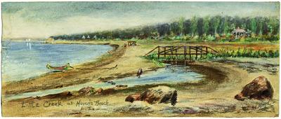
A landscape painting by the late Annie Cooper Boyd shows a small stream that was called Little Cream making its way through a marsh by Havens Beach. Both the marsh and the stream are long gone.
Sag Harbor Historical Society
By
Larry Penny

The Village of Sag Harbor is more of a harbor municipality than a beach haven. There are beaches on all sides, Long Beach on the west and Ninevah beach on the east near the East Hampton Town line. My tax map book for Sag Harbor shows a possible East Hampton ownership tag for the outer beach sands lying between Sag Harbor’s Havens Beach Park and Northwest Harbor. The dredge spoil deposited on Havens Beach in the spring of 2018 was full of a bunch of curiosities including pieces of concrete, crockery, rusted hunks of metal, and other junk. The beach became more of a junkyard than the sandy beach it was prior to dredging.

Suffolk County did the dredging, but the work, which should have been screened by the village’s harbor committee, didn’t really have an overseer, or it would have been stopped shortly after it started. Apparently the collection of stuff from the harbor floor was not properly screened, thus accounting for the various largish objects and blackish underlay that now makes up a good part of the beach.

A Havens Beach group formed as a result of the strange collection of materials and this group gave an eye-opening presentation replete with maps and narrations to a packed house at the recently redone Sag Harbor Library last month.

There were three presenters, Carol Williams, Jean Held, and Terry Sullivan, all of whom were regulars at the beach for a long time before the dredging. The slide show featured early photographic representations of Havens Beach, as well as an early landscape painting done by a resident of Sag Harbor, the late Annie Cooper Boyd, in which a small stream by the name of Little Creek could be seen as it went through the marsh that was once a large part of the Havens Beach Park parcel. Thus, there was once a third creek entering the headland of Northwest Harbor in addition to Little Northwest Creek, which separates Sag Harbor from East Hampton and Northwest Creek, the largest of the three. 

Little Creek and the salt marsh that surrounded it are no longer, having been filled in with sand and other soil materials over the course of the 20th century. I looked on one of my historical United States Coast and Geodetic Survey maps, dated 1888, and sure enough, Little Creek and the salt marsh were still extant, if not in name, at least in substance, as of that year. Instead of Little Creek, now there is a longstanding man-made ditch that collects rain runoff from a fairly large watershed basin on Sag Harbor’s east side and shunts it through a pipe under Bay Street out into Northwest Harbor. Unfortunately, the culvert under the road is too small to pass all of the water through in a timely fashion and after a large rain or snow melt the water backs up and floods nearby basements and yards.

One of the saving graces of the eastern portion of Havens Beach Park, which was spared from the corrupt dredge spoil, is a large, partially vegetated sand-filled area where gulls, fish crows, some shore birds, and other bird species gather from time to time.

Before the dredging, the beach was a popular area for local dogs to not only visit, but also to defecate, to the degree that one smelly eyesore was replaced by yet another, or, maybe, there are two smelly eyesores present now instead of one.

It is still a mystery why the harbor had to be dredged at all by Suffolk County’s Department of Public Works. Some postulate that it was dredged to accommodate bigger boats with bigger and deeper hulls. Part of Sag Harbor’s fascinating history is its harbor, which has earned quite a reputation in the past for accommodating big boats, ships, even. It was the first customs port in New York State and one of the East Coast’s biggest whaling ports during the 1800s.

Larry Penny can be reached via email at [email protected].
Tagging Great White Sharks for Research

Tagging Great White Sharks for Research

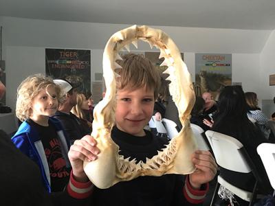
Rupert Angelin, 7, of Amagansett held the jaws of an eight-foot-long great white shark that was found dead on Cooper’s Beach in Southampton and recovered for scientific study.
Johnette Howard
Long Island waters are the only confirmed nursery for the threatened shark
By
Johnette Howard

As videotaped footage began playing of Greg Metzger battling a juvenile great white shark he had just hooked near Jones Beach using just the fishing rod and reel he was gripping, it was easy to momentarily forget the scientific nature of the project Mr. Metzger and the South Fork Natural History Museum are engaged in, and marvel at the spectacle. 

The shark’s teeth were bared and its gills were flaring; its tail thrashed around as it raised its head out of the water toward the boat Mr. Metzger was on, and then tried to shake free.

Mr. Metzger’s rod was bent into a large quivering ‘C’ as he moved back and forth along the boat’s side rail, occasionally fighting to keep his footing as he tried to pull the shark in. Even if it was just a juvenile — great whites are four feet long at birth — it was only natural to wonder how Mr. Metzger avoided getting pulled into the water himself as he waited for the shark to tire out so his crewmates could lasso its tail, do a scientific workup, and tag its dorsal fin before releasing it.

It’s a drill Mr. Metzger and fellow researchers have now successfully repeated 23 times to help SoFo’s three-year-old shark research and education project get the data used to establish that Long Island’s waters are the only confirmed nursery for great white sharks in the North Atlantic.

“The number-one question I always get asked is, ‘Don’t you need a bigger boat?’ ” Mr. Metzger said with a laugh, knowing it’s a repeated line in the movie “Jaws,” not just a reasonable question about the modest 21-foot Parker boat he uses to catch and tag juvenile great white and thresher sharks from Manhattan to Montauk.

“But one of the things we want to do is get ahead of the ‘Jaws’ craze and educate people about how fantastic it is to have these sharks in Long Island’s waters, and how it fits into the bigger ecological picture,” he said. 

Mr. Metzger described the program’s 2018 season for a near-capacity audience Saturday at the SoFo Museum in Southampton. He is a marine science and aquaculture teacher at Southampton High School and the field coordinator for SoFo’s shark research and education program. The program’s other principals include Frank Quevedo, SoFo’s executive director, Dr. Tobey Curtis, the SoFo program’s lead scientist, and Chris Paparo, a photographer and writer who has been documenting the group’s work and manages the Marine Science Center at Stony Brook Southampton College. Other researchers and students collaborate as well.

Last year, Mr. Curtis, Mr. Metzger, and six colleagues published a peer-reviewed article about their research for the first time in the prominent science journal Nature.

Mr. Metzger knows many people are either highly fascinated or slightly nervous to learn that sharks of all sizes, but especially great whites, summer in the Atlantic off Long Island in large numbers, along with threshers, makos, and tiger and sand sharks.

But experts agree surfers and swimmers have little reason to fear, especially if they use common sense. The risk is never zero, and you certainly don’t want to go near a school of bunker or even seals, food sources for sharks, Mr. Metz­ger said, noting that in the 100-plus years shark attacks on humans have been tracked in New York State, only 12 “negative interactions” have been confirmed.

“So, the chances are absolutely minuscule that you will have a negative encounter with a shark,” Mr. Metzger said.

Still, observers have a sense — accurate or not — that shark activity is increasing, perhaps because of climate change, or perhaps because great white sharks’ numbers seem to be rising since they became a protected species in federal waters in 1997 and state waters in 2005. A revitalized seal population could also be drawing sharks closer to shore.

Last summer, two children were bitten and slightly injured on separate Fire Island beaches on the same day, but officials never confirmed whether sharks were responsible or a large fish. Farther north, a man was killed by a shark off Cape Cod, raising further alarm, although it was the first fatal shark attack in Massachusetts in eight decades.

Mr. Metzger said sharks usually arrive on the southern shore of Long Island as early as May and typically head south by October toward the warmer waters of the Carolinas and Florida. Then the cycle repeats itself.

Mr. Metzger and his fishing cohorts use two types of tags on juvenile sharks. The most common is a satellite “pop-off” tag that collects data for 28 days. The second is a $12,000 CATS (Customized Animal Track Solutions) camera that Mr. Metzger and, more recently, Jeff Neubauer, a teacher at the Bridgehampton School, got funded to use for  the SoFo program. Both types of tags are attached to a shark’s dorsal fin.

“The CATS cam is the most sophisticated tag you can put on an animal,” Mr. Metzger said. He explained that it provides information such as the temperature and depth of the water, the angle and acceleration when an animal changes direction, and where it travels. “Plus,” he said, it has a high definition camera, so we can literally see what the animal sees. It’s like you’re strapped on its back.”

When Mr. Metzger cued up another video — this one underwater footage of a shark biting his rope and making off with his chum bucket — the audience seemed rapt.

“All you have to do is say great white sharks,” Mr. Quevedo said afterward, “and people are fascinated. They want to know more.”

Nature Notes: Back Scratching

Nature Notes: Back Scratching

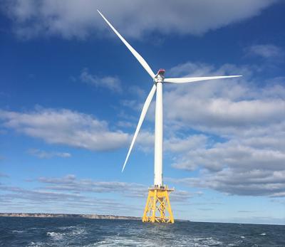
One of the turbines that is part of the Block Island Wind Farm
Dai Dayton
By
Larry Penny

Brrrr. We knew that the mild weather wouldn’t last. So here we are shivering our timbers and wondering what comes next. Then, however, March is only a month away. Let’s hope it’s a pleasant one.

These are the doldrums, but without summer’s traffic and with a large number of snowbirds having gone south, one has to be extremely watchful. There’s always someone in the wings trying to pull something over on when a lot of people are just trying to stay warm and the environment is hibernating. 

The best way to get their attention is with sops, the kind of sops that we are seeing more and more of as Long Island maxes out and is beginning to lose it.

Sops are as old as mankind, but it is only recently that sops in the form of large offers of dough-re-me have entered into the political workings of the East End. The phrase “You scratch my back and I’ll scratch yours” has been part of doing business for thousands upon thousands of years. But, as measured in dollars and cents, it has not been a significant part of doing planning and zoning business here on the South Fork.

For example, an out-of-town corporation called Orsted U.S. Offshore Wind, formerly Deepwater Wind, is offering the leaders of East Hampton Town a package of such monetary sops — large sums of money for this and that town improvement in the hope that those leaders will continue to look favorably upon what they are trying to sell, in this case a package of elixirs called offshore wind turbines. The company assures our leaders again and again that these several-hundred-foot-tall statues with immense twirling blades, once installed in our offshore fishing grounds, will send an everlasting supply of electricity through an underwater tube that will come ashore in Wainscott and then go inland to connect with the electrical grid.

Some sopified members of the town board and town trustees seem to have fallen for these add-ons, notwithstanding that the turbines as seen in the original presentation have gotten larger. 

One of the longest standing political leaders in the South Fork community, however, is not so easily swayed and has just put his foot firmly down, saying, “Enough is enough!” State Assemblyman Fred W. Thiele Jr., who has been a town supervisor and a member of the Suffolk County Legislature, however, before becoming an assemblyman, and has always been a leader in protecting our rural environment, has turned against the offshore wind plan. As it turns out, sops in lamb’s clothing are often wolves.

Not only has Mr. Thiele rejected the sop packages attendant on the Deepwaterl/Orsted offering, he has joined in a suit against another out-of-town company that has offered even a bigger package of sops to the town of Southampton and its hamlet East Quogue, first in the form of a golf course in a large water recharge area, and second in the form of a subdivision and 18-hole golf course in the same spot. 

As you may have read in the local weeklies, East Quogue’s private water wells are already suffering serious contamination from fire-retardant foam chemicals. I ask you, would a golf course and 114 pricey residences not make the situation worse? It certainly would seem so. Three Southampton Town Board members, Democrats, have resisted, while the supervisor, also a Democrat, and the other board member, a Republican, appear to be for it.

Why all of these big sop offers here? One would think that sops in the form of large amounts of money for developmental favors would have no standing as far as the formal and lawful approval of land developments are concerned. Local laws should proscribe such offers, which seem out-and-out bribes on the face of it. In the 28 years that I served East Hampton, its various boards and staff, we never received offers of money for this or that subdivision approval or for this or that wetland permit. However, it is not only on the South Fork that monetary sop offers are gaining prominence; western Suffolk County and Nassau County are already sop ridden, as it would seem from reading Newsday and watching Long Island’s news every day.

So what should we immediately do to protect our natural resources? In my opinion, we should side with Fred Thiele and not be seduced by such offers. If Long Island’s native peoples had been fairly represented before turning over thousands and thousands of acres for a pitiful sop in the form of a handful of coins, tools, and whatnots 300 years and more ago, they would be in a much better stead now, and would not have to beg to be recognized.

—

Larry Penny can be reached via email at [email protected].
Nature Notes: Before It’s Too Late

Nature Notes: Before It’s Too Late

The local drinking water aquifers that we depend upon are being polluted at a rapid rate
By
Larry Penny

The nation is shut down. It’s not for me to open it up. What’s worse to my locally oriented mind, however, is the stuff against nature that has been going down right under our noses here on the South Fork for the past several years. 

The local drinking water aquifers that we depend upon are being polluted at a rapid rate, especially since I first moved back here from California in 1973. First it was the potato beetle killer Temik, next the gasoline additive M.T.B.E., and now it is the firefighting foams PFOS and PFOA. Along with that we’ve been dumping medicines and flushing urine down the drains for a century or more. It’s a wonder that there is any good water to drink or wash with left under our feet at all. The Suffolk County Water Authority does the best job it can under the circumstances and continues to drill new wells into aquifer areas that are still hardly tainted to provide us with good water. But it is treated with chlorine.

People have been mucking up Long Island’s drinking water supplies since before World War II. One has only to read Newsday each day to see how badly we have polluted the underground water supplies Island-wide. The saddest part of the story is that many Long Islanders have been drinking toxic water throughout their entire life spans. No wonder we are such an unhealthy collection of men, women, and children.

Most of our political leaders only react after the whistle is blown. It may not be too late to act, but much of the damage has already been done before they do. I am reminded of a very localized toxic plume on the west side of Three Mile Harbor in East Hampton about 28 years ago when I was the natural resources director of the town. I was informed by a geologist friend that at one house in that neighborhood a pet cat wouldn’t drink the water that came from the tap. I passed the information on to the late Russell Drumm at The Star and he looked into it. Turns out the Suffolk County District Attorney’s office was closely watching that site because of a suspicion of drug-making activity.

If Russell had waited for that department to finish its reconnaissance, which could have taken months and months, the toxic water would have spread underground from one house to another and so on all the way down the gradient. His story summoned the Suffolk County Health Department and the cat was literally out of the bag. Tony Bullock was the supervisor then and wasted no time in getting the Suffolk County Water Authority to extend its pipeline from a little ways north of East Hampton Village several miles north to the impacted area. 

The number of such incidents up and down the Island has multiplied over the years, yet much of our population is still drinking bad water.

Lately there is the Wainscott plume coming from the firefighting foams and other toxins used and released around the East Hampton Airport. The Suffolk County Water Authority has been summoned to the rescue. Unfortunately, many of the consumers of private well water south of the airport have been drinking the poison for years without knowing it. Residents of areas around  Gabreski Airport in Westhampton Beach have seen the same kinds of pollutants in their private well water. 

In Sag Harbor, the village board has voted to install a vehicle impound lot on property owned by the village in the hamlet of Bridgehampton — the old dump. The dump sits in the Long Pond Greenbelt area, which has more than six freshwater ponds, the largest endangered tiger salamander population on Long Island, and a nearly pristine swath of aquatic and upland habitats protected by Southampton Town for at least 20 years now. The New York State Department of Environmental Conservation, which is the state’s number-one guardian of endangered and threatened species, approved the site after a short walk-through. 

The impound area is going to be paved so that the vehicles won’t sink into the soil when it becomes muddy. But where will the rain runoff from the impound area go? Directly or indirectly into the nearby greenbelt ponds, especially into a tiny “deer lick” pond that is immediately down drift of the area to be paved.

The Atlantic Golf Course on Scuttlehole Road in Bridgehampton is a known tiger salamander hangout. The D.E.C. knows it and the Town of Southampton knows it. The information is contained in an environmental impact statement done for the owners of the golf course when the land was still agricultural. I was the one who discovered the tiger salamander breeding area there and wrote it into the impact statement. Yet both the town planning board and the D.E.C. overlooked that information and a few weeks ago permitted the golf course owners to tear up the very spot where the tiger salamander breeding area was sited.

Did you hear? The Southhampton Town Zoning Board of Appeals just overwhelmingly decided that an 18-hole golf course qualifies as an acceptable add-on use for the Hills subdivision in East Quogue. That’s a very, very big accessory use. Might as well amend the present town code to make bowling alleys, stock car tracks, shooting ranges, and spas subdivision accessory uses as well.

The Town of East Hampton is in the process of buying a 4.2-acre piece of land on the west side of Route 114, just outside of Sag Harbor, smack over the deepest part of East Hampton’s aquifer. The town is considering building as many as 20 to 30 units of work-force housing there. The septage flushing into the same small underground area will spoil the aquifer and may be drawn to two nearby Suffolk Water Authority well fields that are still unsullied as of now.

And the same town is on board with the massive turbines set to be installed 30 miles off Montauk in the middle of prime fishing grounds. The electricity produced is to be conducted through cable some 40 miles long that is to come ashore at Beach Lane in Wainscott and travel underground to an inland storage site in East Hampton. 

When one of these large storage batteries goes up in flames it’s like the Fourth of July all over again. Solar panels don’t blow up and don’t have rotors that knock birds out of the sky.

As we head into the new year, it seems to me that with respect to protecting the environment, we are still very much mired in the dark ages. Our underground water supplies are being corrupted at a fast pace, our marine and estuarine waters are turning sour with each passing day. With each new warm season the blue-green algae, coliform bacteria, and toxic phytoplankton masses come on like gangbusters. Each year another of our coastal ponds and tributaries is added to the rapidly growing list of impaired water bodies and is shut down to the public.

Notice, I left out the traffic situation, possibly the worst insult to our environment of all, not just because motorists have to inch along at a few miles per hour, but because it pollutes the air so. Long Island has one of the highest average ozone values in the state (and by the same token one of the highest sinusitis problems as well). 

At least one local politician is speaking up in a profound way on behalf of the environment. State Assemblyman Fred W. Thiele Jr. is an integral part of the suit against the inclusion of the golf course as an accessory use in the Hills subdivision.

Isn’t it time to stop and think these matters through thoroughly before carelessly destroying one more butterfly or honey bee?

Larry Penny can be reached via email at [email protected].
Nature Notes: The Ups and Downs

Nature Notes: The Ups and Downs

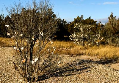
During a bird count last month in the Cedar Point to Grace Estate area, Victoria Bustamante came across these trees decorated with shells.
Victoria Bustamante
2018 was the fourth warmest year for the world on record
By
Larry Penny

One of the big birds counted in the Dec. 29 Orient Christmas Bird Count, which includes North Haven, was the female Barrrow’s goldeneye, seen by Terry Sullivan, who has been covering that territory during annual count for 26 years running. 

Victoria Bustamante covered the Cedar Point-Grace Estate territory. Her biggest find was not a bird but a new tree “species” for the area, the whelk tree (see photo). I’ll have more on the Orient Count and the others that took place across Long Island in the weeks before and after Christmas, but first a look at the warming climate, which may account for some of the newest birds to be tallied on these counts.

It turns out that 2018, was the fourth warmest year for the world on record. The final results are not in yet: So far the warmest year on record was 2016; 2015 was the next warmest, and 2017 was the third warmest. In other words: The four warmest years on record were in the last four years! Something is indeed happening out there. 

As of Monday, the nighttime temperature so far this month in Noyac, where I live, had yet to drop below 26, which is an auspiciously mild start for normally the coldest month of every year since1850.

However warm it is becoming, we must remember that 100 million years ago when green plants were developing, tropical species were trapped and fossilized in Canada. We also should take note of the fact that only 20,000 years ago, the glaciers extended throughout the Northern Hemisphere and reached far down across Asia and into Europe, and into the United States to what we now call the temperate zone, say, almost to Missouri. In the distant past, when oil and coal were being deposited in great volumes underground, heat was generated by other than carbon-based fuels.

Although the burning of fossil fuels must be having a significant effect on the latest surge in warm weather years, the story of the world’s ups and downs in climates and sea level rises and falls is a long and varied one. Seas came and went, some reached inland as far as Kentucky and the rest of the Appalachians, where marine fossils can still be found. Plus, the weight of the glaciers pressed on the land, lowering it. As they melted the land popped up a bit and apparently is still rising in many coastal areas. Ergo, sea level is not only a function of melting glaciers and rising seas, but also of sinking and rising of continental coasts.

I was talking with Jean Held after getting the Montauk bird count figures. When discussing the increase of such southern birds as the Carolina wren, mockingbird, and red-bellied woodpecker, to name few of the southern species now found in northern winters, she commented that all of our birds were once only residents in the south. When I thought about it, I had to agree. Yes, sparrows, robins, warblers, and the like now breed at our latitude and farther north, but during the time of the great glaciers — the ones that created 90 percent of Long Island’s land mass — these birds were not here.

As the glaciers retreated, the birds began to extend their ranges farther and farther to the north, while the few northern species that were present — snowy owls, for example — went farther north, all the way to the Arctic Circle. Migration, which started merely as range extensions in order to decrease the competition for food and nesting areas, kept building, until more than 200 species of what we now call North American birds breed at our latitude and farther north in southern Canada each year. As the late naturalist Gil Raynor once pointed out, a few, such as the great black-backed gull, even extended their breeding ranges in a southerly direction.

Recently, the East Hampton Town supervisor was quoted as saying global warming is likely responsible for the onslaught of the southern pine borer beetle that has been ravaging our pitch pines so badly lately, but what he probably didn’t know is that that same species of beetle has been spreading south into Central America and ravaging pines there, as well. Insects are what we call poikilothermic. In other words, they are cold-blooded; their body temperatures take on the temperature of the air or water surrounding them.

We are losing our eelgrass beds, which is bad for a lot of the shellfish we like to eat and that helped feed the 

irst residents of Long Island — the Shinnecocks, Montauketts, Corchaugs, Poospatucks, and others — for thousands of years before we got here. Some say it is the rising temperatures of the shallow marine waters in which they grow, but eelgrass, Zostera marina, grows up and down both American coasts and throughout European and Asian seas as well. Ours was probably adapted to doing well in colder temperatures, but eelgrass will flourish again, unless the growing pollution in the Peconics and Great South Bays accounts for much of the mortality experienced here.

Long Island in its first years free from the overriding glaciers came to look like the tundra of the Arctic Circle, then developed slowly into a taiga of larch, spruce, firs, birch, and other species of trees that now grow farther north in a band that circles the Northern Hemisphere. The white pines that make up the southern portion of parts of the North American taiga still grow in the Northwest area of East Hampton Town, but very rarely elsewhere on Long Island.

Certainly it would slow things down a bit if we all drove around in electric vehicles that derived their energy from solar panels, not by burning gasoline, but we have to be careful in our prognostications about climate change: It is highly unlikely that oil, gas, and electric heat will be converted overnight into heat from the sun or wind, although many politicians have promised such a complete metamorphosis in as little as 10 to 20 years from now. In the meantime, I’ll try to enjoy the warmer winters, as the thought of becoming a snowbird and overwintering in Florida every year doesn’t excite me at all.

Larry Penny can be reached via email at [email protected].
Nature Notes: A Long Way to Go

Nature Notes: A Long Way to Go

One suggestion from The Star’s “Nature Notes” columnist for improving air quality, not to mention noise levels: Rake leaves, rather than machine-blow them.
Durell Godfrey
I’ve been an optimist all of my life and I don’t know why
By
Larry Penny

Here we are starting a new year and who knows where it will take us? I’ve been an optimist all of my life and I don’t know why. Was it because I was born at home and attended to by Dr. Luce of Riverhead who made more house calls than he had office visits? These last few years, however, I am beginning to see the world through blurred lenses. Sure, we have made a lot of progress locally, we’ve saved a lot of woods, fields, wetlands, sand dunes, ponds, and creeks, but we have a long, long way to go.

When I started writing this column in the early 1980s, East Hampton and Southampton Towns didn’t have laws protecting wetlands. Woodlands were being cut down and turned into housing projects. The local fishermen, who had for centuries provided fresh fish for thousands of customers by working together haulseining, were losing their longstanding rights at a rapid pace.

We’ve come a long way since that time with respect to saving our natural lands and our farmlands, but it took a lot of effort to achieve these milestones. The Peconic Land Trust under John v.H. Halsey’s leadership, which for more than 40 years has already made untold gains in saving our historical farming way of life, continues to work with the East End’s farmers to farm more and build less, while the fishermen are still faced with several impasses and their fate is far from rosy.

We are facing rising sea levels and an increase in the frequency of tropical cyclones and northeasters. Our traffic congestion problems grow worse each year. Our sole source aquifer continues to degrade as our water quality laboratories continue to expand testing and gifted volunteer groups continue to test the local surface waters, but still we often find out much too late that we have been drinking and washing in well water laced with this and that chemical for several years. The nitrogen and other contaminants from septic systems have been increasing and slowly dumping into the local estuarine waters, sullying them more and more.

The air we breathe is clogged with chemicals from exhaust, furnaces, vehicles, and other energy use sources. We have even learned lately that our ozone levels, because of the heavy volume of exhaust from traffic on Long Island roads, are among the highest in the nation. And there seems to be a phenomenon called global warming afoot that some say will change our way of living forevermore.

Here are some practices that are already in use that can be expanded to improve the outcomes for our air and water: 

1) Let green grass lawns turn into moss lawns, which don’t require water or fertilizers to grow and stay green and weed-free all year around. Such transformations will happen on their own if we let them.

2) Rake, don’t machine blow, leaves to manage them. Compost the leaves or let them lie to compost on their own.

3) Walk more, bike more, take fewer auto trips, and use public transportation when and where available.

4) Don’t flush medicines and other personal-use chemicals down the sink or toilet.

5) Use energy saving non-incandescent lights and stop lighting up the world around you with lights that send their rays beyond your property limits. Turn lights off when not in use!

6) Solarize your roofs to lower your use of burning-fuel-source electricity.

7) Eat as much raw food as cooked food.

8) Go to bed earlier; get up earlier.

9) Don’t shower every day.

10) Carpool when possible.

And most of all, enjoy nature!

Larry Penny can be reached via email at [email protected].

Nature Notes: Birds Abound in Montauk Count

Nature Notes: Birds Abound in Montauk Count

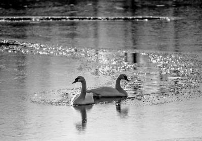
Mute swans, like these photographed a little farther west, were seen in decent numbers during the Montauk Christmas Bird Count on Dec. 15.
Max Philip Dobler
A total of 118 species were seen and counted under the direction of Karen Rubinstein
By
Larry Penny

On Dec. 15 one of the oldest Christmas Bird Counts took place in East Hampton, the Montauk Count. Seven territories were covered by different observers — Montauk Point north, Montauk Point south, Lake Montauk west (including Hither Hills), Napeague, Accabonac in Springs, and the annual plum, Gardiner’s Island. In an unofficial tally of 5,501 birds, a total of 118 species were seen and counted under the direction of Karen Rubinstein. 

Among the winter-resident birds counted were 477 white-throated sparrows, 8 white-crowned sparrows, 40 snow buntings, 136 juncos, 5 purple finches, 1 redpoll, 45 pine siskins, 35 fox sparrows, 2 tree sparrows, 27 yellow-rumped warblers, 38 hermit thrushes, 5 winter wrens, 13 saw-whet owls, 1 snowy owl, 1,898 razorbills, 4 Iceland gulls, 281 gannets, 2 rough-legged hawks, 6 red-necked grebes, 71 horned grebes, 496 common loons, 2,469 red-throated loons, 1 Barrows goldeneye, 2 harlequin ducks, 1,445 common eiders, 830 long-tailed ducks (formerly, old squaw), 283 bufflehead, 74 ruddy ducks, 3 common mergansers (a low), 31 hooded mergansers, 43 greater scaups, 8 canvasbacks, 458 surf scoters, 961 black scoters, and 2,806 white-winged scoters. In duck hunter parlance all scoters are called “coots.” 

It is not surprising that of the 4,225 scoters in total, more than half were in the Gardiner’s Island area, which sees comparatively less waterfowl hunting than the six other survey areas. The same can be said for horned grebes (not a game species). More than half were observed in the Gardiner’s Island count area. Scoter species are usually found in high numbers during the winter in the Long Island area, but the 1,445 common eiders counted is unusual. Global warming may be stunting some local species with respect to breeding, but it seems that common eiders may be given a breeding boost. The same may be said for the 281 gannets observed.

Global warming may account for the large number of spring and summer breeders such as the large number of stay-behind robins (673), song sparrows (585), catbirds (56), and red-winged blackbirds (53) counted. 

Many bird species that used to show up in the winter on earlier counts that I attended on Gardiner’s Island — purple finch (5), red crossbill (0), common redpoll (1) — were either lacking altogether or in very short supply.

Lastly, those birds that are generally here all year, such as crows, herring gulls, and the like, were in good supply. There were 381 of the former and a whopping 1,795 of the latter counted. There were 481 chickadees, 88 tufted titmice, 431 blue jays, 186 Carolina wrens, and 247 mourning doves observed. Only one of the latter was seen on Gardiner’s Island, where birdfeeders are very few or none at all.

Some of the unusual occurrences were the two ravens observed in the Accabonac area, the two pipits counted in Montauk south, and the four tree swallows and one rough-legged hawk on Gardiner’s Island. Birds that are not “natives,” such as the starling (623), mute swan (21), house sparrow (133), and rock dove (219) from Europe, and the house finch (101) from the southwestern United States, are apparently holding their own.

Wild turkeys, which used to be here on Long Island but were missing for almost 200 years, are back in good numbers now. Seventy-five were counted in all, 43 on Gardiner’s Island, where they have been since the early 1960s. 

Pretty good day’s work, don’t you think? Nice job, Karen!