Nature Notes: The Edge of the Sea

Nature Notes: The Edge of the Sea

Is the world’s shoreline length increasing or shrinking?
By
Larry Penny

   The edge of the world’s oceans is the shore, and it is continually modified by storm times. It comes and goes, builds and jettisons. In areas where rocky land masses dip directly into the sea, the shore may be less than two feet wide on average. Where more sand is delivered than taken away, the shore, then the beach, can be hundreds of feet wide. There is no surface geologic formation in the world longer than the shore.

    If you were to measure the shorelines of the five continents and the one supercontinent, Eurasia, and add those distances up, you would get a figure of about 115,500 miles, that is about two and a third times larger than the circumference of the earth taken at the equator. To travel the world’s entire marine shoreline by boat, riding night and day at say at an average speed of 10 miles per hour, it would take approximately 11,550 hours, or 481 days. No one has ever done so, so we don’t have a Guinness Book of Records figure for such an ambitious excursion.

    Is the world’s shoreline length increasing or shrinking? That is the one of the major questions posed by global warming. As sea level increases, in almost every situation, the shoreline recedes. When an island or a salt marsh drowns, as is happening in Jamaica and Chesapeake Bays, the shoreline moves landward. In some northern areas of North America and Eurasia, such as the coast of Alaska, the shore is building seaward. The land is rising. As the glaciers melt away, the land becomes lighter and thus is buoyed up. When the glaciers have melted away completely, the land under them will reach it highest elevation, approximate to that prior to the last ice age, 15,000 to 20,000 years ago, as the glaciers melted back toward the Arctic Circle.

    Of course, all that melted ice water is freshening up the seas, but that’s a topic for another day. Eurasia, including the British Isles and Japan, has the longest coastline, more than 40,000 miles long. North America, including Greenland and Central America, comes next with about 32,250 miles, then Africa with 16,900 miles of shore. The seventh continent, Antarctica, has the least, only 6,000 miles of it.

    Millions of years ago, the world’s collective coastline was considerably shorter, as South and North America were congealed with Europe and Africa. The Atlantic Ocean was only a dimple. The two continental systems are moving away from each other at a rate of a few millimeters a year. At the present rate of separation, the two plate systems will have moved apart by a few meters in a million years, by a more than two kilometers in 100 million years, and so on and so on. That’s how the three species of freshwater lungfishes in the world ended up in Africa, South America, and Australia: They drifted apart from their progenitor species.

    You can find marine fossils loosed from the sides of Kentucky rockslides. How did they get there? Well, the seas reached all the way to the Midwest before orogenesis created the Appalachian Mountains, which raised the level of the land well above sea level and the seas receded hundreds of miles to the east. In the American West marine fossils can be found on the west side of the Sierras and in Arizona. Where did all this water come from anyway? The prevailing theory is that the earth was dry or almost dry until bombarded by comets, which are mostly made of ice. How many comets created the world’s oceans and how large were they on average? Those are questions still to be answered by astrophysicists, astronomers, and geologists. And come the next ice age — there have been several — coastlines will shrink, shores will widen, and we might be right back where we started 15 millennia ago.

    Some people prefer the mountains. Some prefer slow moving rivers and rapid running streams. Born on Long Island’s North Fork in Mattituck, which is low in elevation and has no rivers or streams, I was raised with a limited hydrologic view, but at an early age I did learn about the seas and many of their mysteries. I lived a few hundred yards from two of what are now known as national estuaries — the Long Island Sound and the Peconics — two of the 20-plus in coastal America. Physiologists and medical doctors tell us that our vital fluids are not so different from seawater. Saline is still administered in lieu of blood in some emergencies.

    My vital fluids must be very similar, as the thought of living somewhere inland away from the edge of the sea sends me into a tizzy. The beat and lapping of the waves is not so different in meter from the beat of the sea person’s heart. A sea without tides and waves is not a sea according to my personal lexicon.

    While exobiologists search for extraterrestrial life in meteorites, which could provide one explanation for the origin of life on Earth, most of the scientists trying to explain life’s origin, the first fossil evidence of which now dates back to more than eight billion years, believe that life originated in the soup of salts and organic molecules found at the seas’ edge, not unlike, perhaps, the soup froth that we see on occasion in the wake of the receding waves. We do know that many, many invertebrates and fishes evolved in seawater, but we still have a long way to go before we know for certain just how life originated here.
Nature Notes: Land of Ponds

Nature Notes: Land of Ponds

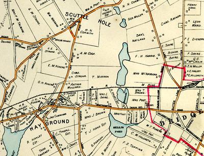
A long pond system rising north of Scuttlehole Road in Bridgehampton includes Short’s Pond, Haines Pond, Goldfish Pond, Long Pond, Little Long Pond, and Kellis Pond at its southern end, as depicted in E. Belcher Hyde’s 1916 “Atlas of the Ocean Shore of Suffolk County.”
The August rains have already raised the level of water table ponds and kept perched ponds in business
By
Larry Penny

   Before I begin, I received an inquiry from Jim Monaco, a book publisher who lives in the south Sag Harbor hills, about deer and the underbrush. He has no ladyslippers, lilies, or other pretty flowers in the groundcover of his nearby woods, only huckleberries and blueberries. True, deer eat orchids, lilies, and other pretty flowers, as do rabbits, squirrels, and other wild beasties in our area. But it is the blueberries and huckleberries that filter nutrients and other dissolved constituents carried in the rainwater that percolates down through the soil layers and into the fresh glacial aquifer, a source of much of our drinking water on the East End.

    Jim also observed that the tick population in his neck of the woods is way down. I’ve heard similar stories from hikers in Montauk and elsewhere on the South Fork. Wouldn’t it be grand if some new disease or predator is hitting on the local tick population and knocking them off? It remains to be seen. On the other hand, the mosquitoes are hitting on us fast and furiously throughout much of the area. Prolonged dryness is the only situation that does them in, save for the application of pesticides.

    And it is anything but dry. The August rains have already raised the level of water table ponds and kept perched ponds in business, as well. In a column on ponds two weeks ago, I failed to mention two of the most important and unique pond systems on the South Fork, the two long pond systems that run from north to south. One of them links the Peconic Estuary with the Atlantic Ocean, the other comes close. The chain of ponds between Sagaponack and Sag Harbor is the largest and the most ponded of these two systems. Starting with Otter Pond on the north, no less than 13 ponds, some of them mere dimples, link the ocean with the bays. In actuality, Otter Pond, the only one that is regularly tidal, doesn’t share the same watershed as the other 12, but it probably did in the near geologic past.

    After Otter Pond comes Round Pond, Lily Pond, Long Pond, Little Long Pond, Crooked Pond, Slate Pond, Black Pond, Little Poxabogue Pond, Poxabogue Pond, Jeremy’s Hole, and, lastly, Sagg Pond, which is a coastal lagoon that is frequently opened to the ocean. Two of the dimple ponds are Fore and Aft, named so by some early Sag Harbor mariners, no doubt.

    In dry times, such as the record drought of the 1960s, some of these ponds, among them Poxabogue and Round Ponds, almost dry up completely. During very wet periods, they overflow their banks and almost become one.

    The ponds north of the divide recharge water to the north. Long Pond is the largest of these and in wet years pours out into Ligonee Brook, which different from the ocean’s winter flounder stock. It remains to be seen.

    The other long pond system rises north of Scuttle Hole Road in Bridgehampton, just south of the moraine. Its watershed is completely southerly directed, ending up at Kellis Pond south of the Bridgehampton Commons. From north to south Short’s Pond starts it off, then comes Haines Pond, Goldfish Pond, Long Pond, Little Long Pond, and finally Kellis Pond, south of the highway. This other Long Pond, as well as Kellis Pond, are approximately the size of the Sag Harbor Long Pond. This second Little Long Pond is mostly covered by woody shrubs. As such, it is a favorite of wood ducks.

    Both pond systems, especially those without big fish populations, are host to the eastern tiger salamander, which is New York State-endangered. They also contain some interesting native fish such as pumpkinseeds, yellow perch, and mudminnows. They are great waterfowl gathering areas, particularly Short’s Pond next to the Atlantic Golf Course, and have many rare plant species, some of which have been overrun with that rampant enemy from Eurasia, Phragmites australis. Some of these rare plant species, such as the rose coreopsis, only appear when the pond levels are low and there are wide areas of exposed shores through the growing season.

   Fortunately, the bottoms (and the ponds on top of them) are publicly owned, that is, by the Southampton Town Trustees, that august body which was given the rights to all of the freshwater ponds in the town by way of the Dongan Patent issued by the New York governor while the British were still in control of America.

    I also forgot to mention a third chain of ponds, the Seven Ponds of Water Mill, which are in the greater Mecox Bay watershed and, if two ponds can make up a chain, a fourth — Big and Little Fresh Ponds in the hamlet of North Sea. Two ponds in these last two systems receive spawning alewives from adjacent seawaters: Mill Pond by way of Mecox Bay and the Atlantic Ocean and Big Fresh Pond by way of an overflow stream to North Sea Harbor. This latter breeding population is one of the oldest in New York State and one of the very largest. Year after year it never fails to produce; at times hundreds of thousands of fingerling alewives run to the sea come August and September.

    Surely, if Minnesota is America’s Land of Lakes, Long Island’s South Fork might be her Land of Ponds!

A World of Experience

A World of Experience

Capt. Kenny Bouse will be honored as part of this weekend’s Montauk Grand Slam charity fishing tournament held from Uihlein’s Marina and Boat Rental.
Russell Drumm
A life right out of a Hemingway novel
By
Russell Drumm

    Kenny Bouse described how he and his brother began their fishing careers in Montauk 62 years ago this way:

    “We took off from Bay Shore on an old ’51 flathead Harley. We didn’t know where the hell we were going. We got to the Lighthouse. I said, ‘What do we do now that the road stops.’ We found some Bubbies haulseining and they told us how to get to the docks.”

    “My brother Davy Crockett scored a job with George McTurk on the Frieda M. I got a job right away on the High Seas, a Florida boat.” The late David Bouse, who served with the Navy’s Underwater Demolition Team, precursor to the SEAL teams, later served as mate to the Montauk Monster Man, Capt. Frank Mundus, on the infamous shark-fishing boat, Cricket II.

    Captain Bouse will be honored as a fixture of the Montauk fishing community during the annual Montauk Grand Slam charity tournament for inshore species held from Uihlein’s Marina and Boat Rental on Saturday and Sunday. The event benefits the East Hampton Kiwanis Club and the Montauk Friends of Erin.

    Captain Bouse should be honored for living a life right out of a Hemingway novel.

    “I worked on the docks in Bay Shore. Got my first job on a boat when I was about 9 years old. In ’53, I went in the Army. I was in the Far East and ended up in Germany with the 18th Combat Engineers. It was the cold war and we worked with explosives on the East Zone outskirts.”

    “I came back to Montauk but then started bumming around. Did a tour in Cuba,” he said, hinting at some mercenary training work alongside of “ex-Germans, Americans, Foreign Legion deserters.”

    “I fished here, and then I would go south. I did a tour down in Australia in the early ’60s with a guy running a boat out of Cairns in the north of Queensland for black marlin. It’s the tropics, 115 degrees in December. The rain forest comes down out of the mountains to the coast. Over the mountains is the Outback — desolate. They say on a clear day you can see the mountains of New Guinea, but I never did. I was up there on a motorcycle,” he said, no surprise to Montaukers. “I’ve been riding for 70 years.”

    Bouse said, he ran private boats in Florida and the Bahamas. “Young Frank Tuma talked me into charter fishing. He got me a slip at Duryea’s,” Bouse said, referring to the dock next to the town’s commercial wharf at the end of the West Lake Drive extension. Captain Bouse was as familiar on the Peggy S, a boat he fished out of Montauk for 37 years, as he is on his Harley now.

    “I stopped fishing two years ago. I got sick four years ago — cancer. The doctor said ‘You’re in stage four. You got about a month. Being a realist, I didn’t panic. Shit happens. I did what they said — chemo — and I’m still around. I could have kept fishing, but my heart wasn’t into it. I felt like I wasn’t giving my customers my best.”

    That’s debatable, of course. Fishing and listening to the stories of the soft-spoken seaman with a world of experience would surely make for a good day.

    Speaking of good days, the West Lake Marina in Montauk reports very productive tuna fishing offshore in and around Block Canyon. Bigeye tuna in the 100-pound range were biting last week with smaller yellowfin mixed in.

     The tournament from Uihlein’s this weekend will be well attended by local fishermen, and if things remain the same as they’ve been in recent days, it will be well attended by fish.

    Those competing in the tournament are judged by the heaviest aggregate weight of the four biggest fish caught of the targeted species: fluke, striped bass, bluefish, and black sea bass. False albacore are not among the targeted fish, but they, too, are around, according to Harvey Bennett of the Tackle Shop in Amagansett.

    Falsies have been taken around the Ruins on the north side of Gardiner’s Island. Bennett is also crowing about the number and size of the porgies in Gardiner’s Bay, and he has announced he’s back in the light-tackle and fly-fishing charter business.

Nature Notes: The Rising Waters

Nature Notes: The Rising Waters

A now-submerged island in the northwest part of Fort Pond in Montauk was so high and dry 90 years ago that the remnants of an upland forest grew there.
Victoria Bustamante
The record June rains supplied enough water to sufficiently raise the water table
By
Larry Penny

   The water is rising. Well, not all over, but in many places locally. Chatfield’s Hole in East Hampton’s Northwest is well and good, having almost dried up last summer, as are all of the other ponds in that area — Staudinger’s, Crooked, Two Holes of Water, Scoy, Little Scoy. and Wood Duck Ponds. The quiet little pond that wants a name, just north of Swamp Road where it meets Two Holes of Water Road is so full that it now runneth over into Northwest Creek.

    All of these ponds are groundwater-fed and thus rely on rain to keep them full. The record June rains supplied enough water to sufficiently raise the water table and keep them all afloat. Daniel’s Hole on Daniel’s Hole Road north of the East Hampton Airport, on the other hand, is 100 percent covered with wetland vegetation and is almost dry. It is perched well above the water table and is completely dependent on rain and runoff for its water.

    Wolf’s Hole, another pond above the water table, between Two Holes of Water Road and Route 114 north of Stephen Hand’s Path is only slightly wetter than Daniel’s Hole. The Suffolk County Water Authority’s deep-water supply well a few hundred yards to the south depresses the water table in that area, so Wolf’s Hole requires a lot of rain to keep it wet.

    The 16 coastal ponds oriented north to south along the south shore of the South Fork, beginning on the west with Halsey Neck Pond east of Shinnecock Bay inlet and ending on the east with Hook Pond in East Hampton Village, are all groundwater ponds. They are all remnants of a long seawater bay that no longer exists. Mecox Bay, Sagg Pond, and Georgica Pond from west to east are annually opened to the ocean once or twice, become tidal, and thus are brackish.

    Inasmuch as the aquifer turns up along the south shore, the landlocked of the 16 ponds such as Wainscott Pond and Lake Agawam almost always have enough water to keep them full, and more often than not, too full.

    Springs has its Pussy’s Pond and Amagansett has Fresh Pond, both of which are partially tidal, while Napeague has lots of little wet spots called dune slacks in which cranberries and orchids flourish, as well as two fair-size seasonal ponds south of the highway just west of Hither Hills State Park. When these last two ponds fill up after heavy rains that elevate the water table, muskrats leave their burrows and build wickiups of reeds and other vegetation to live in and raise a family.

    The hamlet of Montauk has more freshwater wetlands and freshwater ponds than any other place on the South Fork. To start with, Fresh Pond, or Hidden Pond, in Hither Woods is, perhaps, the most oligotrophic pond — clear and sediment-less — in East Hampton Town. It is a water-table pond and has a nice complement of freshwater fish. Only a year ago, it had a beaver living in it that only a few people saw, but lots of people saw the trees gnawed through and fallen that the beaver left behind. Interestingly, the fish there are rather high in mercury, attributable to the atmospheric mercury gleaning ability of the pond’s surrounding wetlands.

    Indeed, up until the mid-1920s, Montauk was host to the largest freshwater pond on Long Island, Great Pond or Lake Montauk. Great Pond was always a couple of feet higher than sea level. When it got really full, it would overflow into ditches, such as the Oceanside drain, that ran south to the ocean through Ditch Plain. Now that it is tidal, it always drains north into Block Island Sound.

    The second largest pond on Long Island after Lake Ronkonkoma, Fort Pond used to be opened to Fort Pond Bay on occasion, but that all stopped when the Long Island Rail Road was put through to the north around 1900. Now when it builds up, as it did to record heights in March of 2010, the water is trapped and has no place to go. It is still very high at the moment.

    The island in the pond’s northwest sector was high and dry in 1923 when Norman Taylor published his “Vegetation of Montauk.” It was so high and dry that the island, once called Brushy Island and lately known as Turtle Island, was populated by a remnant of upland woods including an American basswood, the only one to be found in Montauk at the time. Later tupelos populated the island. Today the tupelos are all dead and the water level overtops the onetime forest floor.

    Since Fort Pond is a water-table pond, it will continue to get higher and higher in lockstep with the ever-rising sea level as freshwater is lighter than saltwater and is buoyed up by the underlying seawater. The same thing will happen to Star Island in Lake Montauk, but in a slightly less dramatic fashion.

    Big Reed Pond, east of Lake Montauk in Suffolk County parkland, may be the richest freshwater body on Long Island, botanically speaking. Its wet edges have five or more higher plant species that you would be hard-pressed to find elsewhere on Long Island.

    Oyster Pond to its east is an intermittent tidal pond, much like Georgica and Sagg Pond. High seas regularly overwash the bay mouth barrier separating the pond from Block Island Sound and after Sandy’s visit last fall, water levels remained very high right up until the beginning of summer. It has a watershed that stretches all the way south to the bluff tops of the ocean cliffs between Montauk Point and Deep Hollow Ranch, so it never suffers from a lack of water.

    Because Oyster Pond, once Lake Munchogue, is brackish, it is perfect for growing oysters in the same way that the Great South Bay was before its inlets were permanently opened to the ocean. What was perhaps the last Long Island population of the southern leopard frog (or the newly described Staten Island leopard frog) remained in the pond’s upper reaches until the 1990s.

    The South Fork will never suffer from a water shortage, be it fresh or salt. It will, however, suffer from a surfeit of water in the next half century and some of you readers will be around to see the consequences.

Fear and Great Joy

Fear and Great Joy

The Anna Mary, anchored in Fort Pond Bay in Montauk Sunday, served as bandstand at a party to celebrate the rescue at sea two weeks ago of John Aldridge, a co-owner of the lobster boat. Lobsters were in copious supply.
Atilla Ozturk
Anna Mary, the lobster boat John Aldridge fell from on July 24, supplied what seemed like an endless supply of lobsters for the party
By
Russell Drumm

    The party on the banks of Fort Pond Bay in Montauk Sunday celebrated the rescue of John Aldridge after his surviving 12 hours at sea over 30 miles offshore with the help of buoyant rubber boots. He was known as Johnny Load, a nickname with undefined coinage. He is now known as Johnny Boots.

    Anna Mary, the lobster boat he fell from on July 24, supplied what seemed like an endless supply of lobsters for the party. She was anchored just offshore and her back deck provided the stage for music by the band Jettycoon. Members of the Montauk community chip­ped in for the barbecue pig, beer, hot dogs, burgers, salad, etc. The sun that dramatically reappeared after a violent, rain-filled squall seemed a fitting conclusion to a week and a half full of both fear and great joy.

    The joy in Montauk Harbor was short-lived. Word came yesterday morning that Capt. Fred E. Bird has passed over the bar. A complete obituary will appear in an upcoming edition of The Star. Captain Bird, at the helm of the Flying Cloud party boat for decades, was a gentleman and a jazz aficionado. His customers were treated to the sounds of big-band swing music while they fished. He will be sorely missed.

    Weakfish continue to be caught by surfcasters along Ditch Plain Beach in Montauk, as well as striped bass on both bait and lures. There are so many sand eels in the area that swimmers are seeing them in the surf. This could bode well for the fall surfcasting season.

    “Hey, I think that’s a seal looking at us,” Ken Rafferty, a fly-fishing and light-tackle guide, said yesterday morning from an undisclosed location in Gardiner’s Bay where his clients were busy catching small striped bass.

    “The weird part is we’ve had a month of being able to catch and release a hundred bluefish, but now I don’t know where they’ve gone. The west wind has made the water murky,” he said, murky but full of bait including sand eels and something that looks like bay anchovies. “Also a lot of seals, which maybe explains the lack of bluefish,” Rafferty said.

    In the sailing department, Sail Montauk is holding Tuesday night regattas. The organization has four Catalina 22s with three crew positions on each boat. No experience is necessary and each boat has a licensed skipper aboard. Supporters can watch the races from the October Rose, Montauk’s water taxi. The cost is $95 per person.

    The first launch leaves the Montauk Yacht Club at 6 p.m. Reservations can be made by calling 522-5183. The Montauk Chamber of Commerce is offering the second season of its Take a Kid Fishing program. The harbor’s captains and mates are prepared to take kids ages 6 to 16 offshore to learn how to bait, hook, and clean their catch. Fishing equipment, bait, and life jackets are provided. Kids on a boat for the first time will fish for free. Their accompanying adults are charged $10.

    The expeditions will take place on various dates this month starting on Monday. Reservations are being accepted on Monday afternoon at the chamber office on Main Street, Montauk, or by e-mailing [email protected].


Nature Notes: Pick Your Poison

Nature Notes: Pick Your Poison

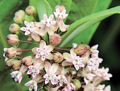
The white, milky sap of Asclepias syriaca, or common milkweed, would do most of us in if we ate it.
Victoria Bustamante
Plants don’t bite, but they can be the most menacing of all the lurkers
By
Larry Penny

   It’s a jungle out there and I don’t mean New York City at night, I mean out there out here. Whether you walk in the woods or through an old field, try to catch a clam or two with your toes, or sit outside at night under the starry sky, at this time of year there is always something lurking, ready to unsettle you.

    Plants don’t bite, but they can be the most menacing of all the lurkers. Poison ivy, or P.I., as it is known to campers, is one of our most common native plants and probably the most feared. I don’t get poison ivy, but I am one of a very small minority that is immune. There isn’t a native or home garden habitat around that doesn’t have a poison ivy plant or two. You can recognize it by its three shiny leaflets in a kind of rosette, but you don’t always see the leaves, and just scraping an ankle or wrist over the bare vines is enough to cause a major eruption.

    Fortunately, poison ivy’s closest local relative, poison sumac, is quite uncommon and you’re not apt to find it on dry land. It’s an obligate wetland species. If you are allergic to poison ivy, then you will be even more allergic to poison sumac. One sumac looks like another and the area is loaded with sumacs of three species, but these harmless ones are all upland plants. Some, like the shining, or winged, sumac, are even grown as ornamentals in estate gardens. Stay out of swamps and you will probably never come in contact with the dangerous variety.

    The stinging nettle is an attractive plant that even invites you to touch it or pick it up. I had my first stinging nettle experience when I was about 13 years old near Saratoga, upstate. It was my last because I learned quickly by way of the so-called trial and error method; I have never touched a stinging nettle since. Fortunately for us on Long Island they are very uncommon, but that may be temporary, as they are widespread in North America.

    Other common local plants that can give some the itchies via contact are the native Virginia creeper and the alien but well naturalized tree-of-heaven. But wait, there is now a new kid on the block, one that can cause not only itching but very serious side effects like vomiting. It’s the giant hogweed, another alien that is rapidly becoming established on Long Island and, in the past two or three years, on the South Fork. If it’s in your neighborhood you can hardly miss it. It gets up to 10 feet tall at maturity with an umbel of small whitish flowers (not unlike the flowering head of Queen Anne’s lace, which is harmless) and its leaves are as large a rhubarb leaves. If you see it, give it a wide berth and report it to a plant person. The last ones I spied locally were on the edge of the cul-de-sac at Quarty Circle in East Hampton and on the shoulder of Daniel’s Hole Road next to Daniel’s Hole, also in East Hampton.

    In order to be victimized by most of our poisonous plants, you have to ingest them. Generally, it’s the attractive fruits that are toxic, but in some, such as pokeweed, it’s the foliage. Just because catbirds and a few other fruit-eating birds are able to eat the fruit does not mean you should try it. It could make you very sick. The fruit of the deadly nightshade, a climbing vine in the tomato family, is black and iridescent, about the size of blueberries. Very tempting, but even the birds quickly learn to stay away from it.

    Like the nightshade, datura, or “locoweed,” is also quite toxic, but its seeds, borne on silky thread in golf-ball sized pebbly pods developing from large white flowers, are the most so. These weeds from the Southwest kill cattle, they also make humans high (before they kill them, too). Datura comes and goes. It grows around the public ocean parking lot in Sagaponack in different years also in the fields along Route 114 north of the Long Island Rail Road tracks from time to time.

    Sheep laurel is a close relative of mountain laurel. It’s a low shrub and not nearly as common as the other. Its foliage is quite poisonous and deer leave it alone. Since most of us modern humans have lost the arts of hunting and gathering, we are not likely to eat sheep laurel leaves if we come across them, and even less likely to eat the evergreen periwinkle leaves in our gardens, which are equally toxic.

    And it is not very likely that we will feed on milkweeds or closely related dogbanes, the white milky sap of which would do many of us in if we ate it. You will find very few herbivores in nature eating either of these two, yet the larvae of red-and-black milkweed beetles thrive on them, as do the caterpillars of the monarch butterfly.

    Mushrooms plucked from the forest floor can be very tasty and nutritious, but the flesh of a single destroying angel, Amanita phalloides, could kill an entire family. Around the world, 50 to 100 human deaths a year are attributed to eating poisonous fungi.

    Then there are the blue-green algae in Mill Pond, Water Mill, and Agawam Pond in Southampton Village that we’ve been reading about, which are very poisonous to some organisms. I think I’ll pass on eating any and will confine my algae eating to sea lettuce, Ulva lactuca, fresh out of the creek.

    Oh, yes, I forgot to mention goats. Curiously, they can eat poison ivy and many other poisonous plants without suffering even a faint spasm. What is it about goats? I’d like to know. Unless you’re a Capricorn, beware; it’s a jungle out there.

Nature Notes Unite Against Interloper

Nature Notes Unite Against Interloper

Such occlusive walls can presently be seen in all their summer glory in Montauk along Old West Lake Drive
By
Larry Penny

   As you ride along some of our scenic routes where you used to be able to get a good look at the water, be it a pond water, the ocean, a bay, or a creek water, you will often find the view obscured by one of the world’s tallest grasses, the common reed, or phragmites. Linnaeus himself in the mid-1700s first described the reed and gave it its first scientific name, the binomen Arundo phragmites, one of thousands he created. Phragmites stems from the Greek for “growing in hedges,” and describes its tendency to form vegetative walls that block the view.

    Such occlusive walls can presently be seen in all their summer glory in Montauk along Old West Lake Drive adjacent to Lake Montauk, along Industrial Road on the north end of Fort Pond, and around Tuthill Pond, just to the northeast of Fort Pond. They are also growing heartily around the back side of Fresh Pond in Amagansett, along Albert’s Landing Road, along Old Stone Highway bordering Accabonac Harbor in Springs, on the north side of Soak Hides Road at the south end of Three Mile Harbor, between Scoy Pond stream and Ely Brook Pond, along Alewife Brook Road in Northwest, then again, on both sides of Northwest Creek and on both sides of Little Northwest Creek as ones drives to the Sag Harbor Golf Course from Route 114 in Sag Harbor.

    The State Department of Environmental Conservation says in no uncertain terms that we can’t touch these tall, thick hedges without a permit, which can cost up to $800 and take years to acquire. That’s because the state’s tidal and freshwater wetlands regulations, written in the early 1970s, considered phragmites, then known as Phragmites australis, to be a native wetland species ranking right up there with the likes of sacrosanct saltmarsh cordgrass and cattails. Since the early 1970s, this so-called native has been taking over wetlands throughout Long Island and much of eastern North America. It has shown itself to be a real bully, but not a “weed” because it was believed to be native, found in all of the lower 48.

    Then along comes a young Yaley named Kristin Saltonstall in the late 1980s and early 1990s, who, using genomic analysis, discovers, “Hey, this thing isn’t native at all; it’s an immigrant from Eurasia.” Ha, ha, the thing we began to hate but couldn’t because it was as American as apple pie, was really a dreadful interloper from abroad. This same woman, now Dr. Kristin Saltonstall of the University of Maryland, went on to describe a native American phragmites, Phragmites americanus, with the help of fellow botanists, but it is very rare, having been overshadowed by the undocumented alien, a very close lookalike.

    Arthur Haines’s “Flora Novae Angliae,” published by the Yale University Press in 2011, has finally put the nail in the coffin. You can tell the bad guy phragmites by its darker to grayish-green leaves, its dull, ridged stem joints (called internodes), and the many fine parallel ridges running along the stem from bottom to top. Aha, I thought, I bet what I have been looking at and scratching my head over for so many years on the South Fork and other parts of Long Island is not the native, but the evil intruder.

    So on Monday I started in Montauk on East Lake Drive and made 13 stops on the way back to Sag Harbor along all of those roads and water bodies listed above to take samples from and photograph the different stands. Wouldn’t you just know it: All of the phragmites at the 13 different sites were Eurasian in origin. They all had those attributes described by Haines and Saltonstall. In other words, because we failed to look below the surface or couldn’t because of technical difficulties (DNA and other molecular analyses to differentiate plants is fairly new), we have been snookered by this wolf in lamb’s clothing, Phragmites australis.

    While in Eurasia some natural enemies have been keeping it at bay, to the extent that it has even become rare in parts of Europe, here it shows no signs of faltering on its march to the sea. The only American phragmites I have ever seen was in Florida, but there are still small patches of it here and there in New England and northeastern Canada, say, Nova Scotia. Both species have a clever way of reproducing themselves, not so much by spreading seed, but by rhizomic extension, i.e., cloning, the way that American beeches, quaking aspens, sumacs, and a host of other native species choose to spread.

    In this respect, the Eurasian species far outguns its American cousin. It can send it rhizomes out 20 to 30 feet over land until the tip reaches the water. The elongate rhizome can put up a shoot every six inches or so. The American version is not so greedy and distributes its offspring much more sparsely.

    Phragmites isn’t all bad. It does remove nitrogen, which would otherwise enter the waterways, from the soil. On the other hand, the relationship between the native eelgrass and foreign phragmites is of interest and needs to be studied more. In those parts of the Peconic Estuary in East Hampton Town, wherever phragmites forms area-wide stands such as at Northwest Creek, Accabonac Harbor, and Fresh Pond, Amagansett, eelgrass has practically disappeared. Along the banks of Napeague Harbor and, to a lesser extent, along those of Lake Montauk, there is not much phragmites and eelgrass is still making a go of it on the bottoms of those water bodies.

    On Monday, I started with East Lake Drive because it is the home of a pond built in 1910 on land donated to the Town of East Hampton. After the pond was done in early summer and the Eurasian phragmites began to make a serious comeback, I cut all of the phragmites on the north side of the pond on more than one occasion. I was proceeding according to a hypothesis recently construed by Karen Blumer, the Long Island author of “Growing Wild,” a book about getting rid of invasives and bringing back native plants on Long Island. The hypothesis simply states that you don’t have to replant with natives once you remove the invasives (or in my case, cut them to the ground); the natives will come back on their own. What did I find? Three years after my first phragmites cutting, and almost two years without subsequent cuttings, I went to look: “My God,” I thought, “Karen’s hypothesis seems to be ringing true.”

    On the south side of Bond’s Pond, named for the man who donated the land, there was a magnificent hedge of foreign phragmites, while on the north side there were native sedges, rushes, verbenas, alders, goldenrods, at least 30 different native wetland and near-wetland species flourishing along with a few straggly phragmites of foreign extraction.

    So let us not wring our hands about people cutting phragmites. They are freeing the wetland edges for the comeback of true natives such as the marsh hibiscus, blue flag, and other American pretties, and maybe in time our own Phragmites Americans. People of the South Fork unite: Hew down bad phragmites, free the wetlands from their stranglehold, validate Blumer’s hypothesis.

They Came to the Surface

They Came to the Surface

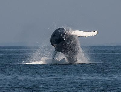
On an offshore trip with Sea Turtle Dive Charters out of Montauk, a humpback whale launched itself out of the water, then returned, white pectoral fins spread wide, for an awesome splashdown.
Dalton Portella
Portella caught the humpback’s launch, slow roll with its long, white pectoral fins spread wide, and its awesome splashdown
By
Russell Drumm

    It’s likely we were put on this earth, or, depending on your point of view, we evolved on this earth, for no other reason than to bear witness. Homo sapiens seem to have no other meaningful purpose. From a global point of view, we tend to muddle things up when we act. Best to just keep our hands in our pockets and watch and, as a few East End witnesses did this past week, marvel.

    “You know, I look out at the ocean all the time from here and think about the whales and all the fish out there, but that day, they all came to greet me. Everything came to the surface,” Dalton Portella said on Monday afternoon from his lawn across Old Montauk Highway from the sea, still excited for having “eaten the marrow” out of July 17.

    Portella, a surfer, photographer, paint­er, and musician, went on a shark-cage dive on July 17 with Chuck Wade of Sea Turtle Dive Charters, which operates out of the West Lake Marina in Montauk. It was one of the final days of the seven-day heat wave. The temperature on land was in the 90s. Offshore was a bit cooler, but still tropical. The charter boat drove 25 miles south of Montauk Point on a flat sea that does not get any calmer.

    “First we saw fin whales and lots of dolphins that came and rode the bow wave. Chuck Wade said fishermen had seen humpback whales breaching left and right off Shinnecock. I was in the cabin of the boat and had just finished a cage dive.” He was about to witness something amazing.

    The shark dive had been a success. The cage, firmly attached to the boat, accommodates two divers at a time and is equipped with air tanks for breathing. Three large blue sharks circled the cage and Portella, using a waterproof GoPro camera, documented their sinuous passes for a series of watercolors he’s been working on. “I had just finished the dive, looked out the window and saw a humpback breaching. I grabbed my camera, went out on the deck and yelled, ‘Do that again!’ ”

    “And it did. Absolutely spectacular. I was in heaven. There were two out there, frolicking, slapping the surface, mating I think.” Portella caught the humpback’s launch, slow roll with its long, white pectoral fins spread wide, and its awesome splashdown. A large shark, probably a mako, was also seen flying out of the water during the trip.

    Montauk’s Viking Fleet of party boats, in cooperation with the Coastal Research and Education Society of Long Island, or CRESLI, has been running whale watch trips on Sundays, and whale witnesses have not been disappointed. 

    Closer to shore the next day, Nick Adams was paddling his standup board in the ocean off Wiborg Beach in East Hampton, looked down and witnessed a stingray at least six feet long and later another he estimated to be longer than his paddleboard, over nine feet. “They seemed happy basking on the sandy bottom in about four feet of water. I’m no fish expert, but I think they were roughtail stingrays,” Adams reported.

     Big manta-like rays are known to visit this area right about now and have been seen in Fort Pond Bay in Montauk this time of year. The roughtails grow to over 600 pounds.

    Also in the look-but-don’t-touch department, a reminder that the SharkEye two-day, no-kill tournament and festival will get under way from the Montauk Marine Basin on Saturday. Brooks and Sean Paxton, known as the Shark Brothers, will be on and will hold a number of educational forums under the tent. Scott Curatola-Wegemann, a scientist with Cornell Cooperative Extension and a shark-attack victim, will talk about why protecting sharks is so important.

    Four of the sharks caught within a proscribed area will be outfitted with GPS tags so they can be tracked via satellite on home computers.

    As Portella said, they all “came to the surface” last week, including a l86-pound bluefin tuna caught aboard Capt. Harry Garrecht’s Breakwater boat. Bill Parmenter angled the fish. It was weighed at the Star Island Marina. 

    Feeding bluefin and feeding whales are often seen together, as happened last week from here to Nantucket. This season’s profusion of sand eels, high on the menus of whales, tuna, dolphin, and a glut of other species, could be the reason for the offshore feast. As this reporter has speculated before, the constant west winds during late spring and early summer, winds that push nutrients out to sea from coastal rivers, could explain the gathering of species including the inhabitants of Gulf Stream eddies and meanders.

    Striped bass continue to be caught on clam baits along Napeague and Amagansett beaches, porgies are getting fatter and fatter in Gardiner’s Bay, the snapper blues are growing in Accabonac Harbor, and there has been a school of very large bluefish around the Ruins on the north side of Gardiner’s Island. Buoy number two has been a hot spot for fluke of late, according to Harvey Bennett of the Tackle Shop in Amagansett. Can I get a witness?


Nature Notes: The Deer Didn’t Do It

Nature Notes: The Deer Didn’t Do It

In our columnist’s opinion, one of the most serious charges against deer — that they are destroying the South Fork’s low woodland vegetation — is off the table.
Dell Cullum
For several years now deer have also been blamed for removing the underbrush or subshrub groundcover across the South Fork
By
Larry Penny

   The native deer population has been blamed for a lot of things, hosting ticks, causing highway accidents and vehicle damage, eating favorite ornamentals, even defecating on manicured lawns. For several years now deer have also been blamed for removing the underbrush or subshrub groundcover across the South Fork.

    My own casual observations over the years gave reason to question this last accusation. Since 1980 I’ve been keeping track of the condition of the woodland vegetation, not only of the trees, but also of the stuff on the forest floor below their canopies. I have seen the groundcover eaten up firsthand, not by deer but by gypsy moth larvae and canker worms after they’ve finished stripping the trees bare. Several areas on the South Fork still bear the scars of these episodic invasions.

    However, this year the insect gods have been kind, there is very little in the way of defoliation on a grand scale to observe. In fact, and perhaps owing to the generous June rains, the canopies have not looked so full and so lush in many years. Having religiously kept track of the state of the tree foliage in Southampton and East Hampton Towns since the beginning of spring, I decided to take a close look at the groundcover situation.

    So, on Friday and Monday I drove the woodland roads of the two towns, east of Southampton Village and west of Napeague.

    In all, I drove 32 miles of Southampton roads and 35 miles of East Hampton ones, recording the state of the undergrowth as I went. The roads covered a collective area of some 29,500 acres of prime woodlands, including East Hampton’s Northwest white pine and pitch pine forest, the morainal pitch pine and oak forests of Southampton, and those of western East Hampton, in Wainscott, for example. I also cruised the woodlands of Amagansett and Springs north of Montauk Highway.

    I have the following good news regarding forest undergrowth: First of all, let me start out by saying that in my 23 years of roadside observations, I have never seen the groundcovers looking so robust, green, and thick. On my 1-to-10 lushness scale, the groundcovers along the roads I traveled consistently rated 9 and 8.5, that is equally as lush as the canopies in the trees above. Except for a few areas where American beech trees are dominant, such as along Old Stone Highway between Amagansett and Springs, where the ground was almost devoid of cover save for the leaves, the floor of every pineland and oakland forest were 30 to 100 percent covered with huckleberries and lowbush blueberries. The average coverage was about 80 percent.

    Similarly, there were no signs of the viral disease that four and five years ago had wiped out many patches of them as well as mountain laurels. The leaves were almost 100 percent green. In a few spots that had been the hardest smitten by gypsy moths, such as along Hand’s Creek and Daniel’s Hole Roads and Stephen Hands Path, all in East Hampton, as much as 40 percent of the groundcover was composed of a 12-inch-high layer of Pennsylvania sedge, another native and the most common sedge species on Long Island. It had come to the ravaged woodlands’ aid after the tree, huckleberry, and blueberry leaves were eaten up by the caterpillar attack of 2000 and 2001.

    As I had hypothesized, there were very few signs of deer.

    What was especially pleasing to discover after two days of driving here and there in near 90-degree weather was that the “water recharge” and “aquifer protection” areas of East Hampton and Southampton, respectively, were almost completely intact. The East Hampton ones were established in 1983. Without the groundcover and the turf layer to filter and remove nitrogen products and other pollutants, the groundwater reserves sequestered in our two potable aquifers, the upper glacial and magothy, would be much less pure than they are today. The administrations in both towns in the 1980s were smart-thinking and smart-acting. Bravo East Hampton and Southampton!

    At least for the moment, one of the most serious charges against deer is off the table. In all fairness to Odocoileus virginianus, shouldn’t we re-examine the others more carefully?


Indonesia: Montaukers’ Surfari

Indonesia: Montaukers’ Surfari

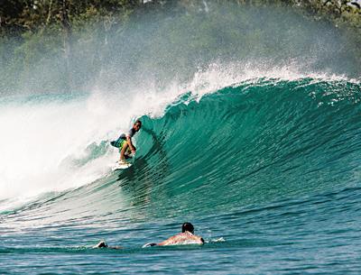
Nick Joeckel found himself in the “green room,” one of many he and 10 friends from Montauk experienced during a surf safari to Indonesia in June.
Matt Clark
The Mentawais are a vast tropical paradise with Indian Ocean temperatures in the mid-80s
By
Russell Drumm

   Nick Joeckel laughed, sort of, in telling how customs agents shook him down for two brand-new pairs of sunglasses in the Jakarta airport on the way back from a 10-day odyssey during which he surfed some of the best waves on the planet with 10 friends who had dreamed of surfing Indonesia together since they were kids.

    They returned on June 22 bruised and cut from bouncing off the reefs of the Mentawai chain of islands, but with surfing batteries fully charged.

    Except for Java Bailey from Southampton, Matt Clark, a well-known surf photographer, and Joe Mata, a rep for Oakley sunglasses — the company that puts Joeckel in the category of sponsored surfer — the trip was made up of friends, now in their mid-20s, who caught the surf bug at Atlantic Terrace, Ditch Plain, Turtle Cove, and their other hometown Montauk breaks.

    Joeckel, his brother, Jesse (who owns the Whalebone Creative shop on Fort Pond Bay), Tyler Maguire, Charlie Weimar, Patrick Havlik, Kevin Becker, Jason Hewitt, John Wade, Bailey, and Mata are experienced surfers who, for years, had traveled beyond their hometown spots to juicier waves in the Caribbean and Hawaii. Nick Joeckel, Weimar, and Bailey had surfed Indonesia before.

    This time, Joeckel, Maguire, Havlik, Wade, and Becker flew to Bali two weeks before the boat trip. Wade is still in Bali, “gone rogue,” Joeckel said. Wade is a commercial fisherman out of Montauk by trade, as are Joeckel and Weimar.

    “As a group, we all talked about a boat trip to Indo,” Joeckel said, referring to the preferred way to taste the wide variety of waves offered by the reefs located over 50 miles off the coast of Sumatra. Beginning in the 1970s, the area was pioneered by Australian surfers who risked malaria and worse to experience wave perfection.

    The Mentawais are a vast tropical paradise with Indian Ocean temperatures in the mid-80s, equatorial sun, and, other than a few island villagers paddling dugout canoes, little else but natural beauty. A surfari to the islands has become a pilgrimage of sorts for very good surfers, but the islands are in the middle of proverbial nowhere. A serious injury is serious indeed. These days a few resorts that cater to surfers have sprouted up, but boats, some with first-class accommodations, Indonesian crews, excellent food, and bottomless supplies of Bintang beer for apres-surf sunsets, are the way to go.

    “Our boat was the Meleleuca, a 70-foot Indo yacht, first-class with an Australian guide,” Joeckel said. “Yogurt and fruit before our first session, then eggs, then a second session, and lunch, then surf again in the afternoon. Three sessions per day.”

    He said the Meleleuca first called at the area known as Playgrounds, named for the number and variety of waves in close proximity, including Rifles, so-called for the cracking sound a wave makes when its perfectly formed lip hits the reef. Not far away, they caught the wave known as Bank Vaults — “double overhead barrels, a loomy peak,” Joeckel said.

    The boat stayed at Playgrounds for the first three days, then headed south to the infamous wave known as Macaroni’s, perhaps because of the way a surfer can get twisted there. The Montaukers were taken to Greenbush, a wave that’s been surfed for only a few years.

    “Heavy reef-break barrels. You come out of a barrel practically onto dry reef. We had it by ourselves for two days, a big, dredging, spitting barrel. No room for errors, no turns, just go. It’s more of a wedge.”

    Joeckel said that Montauk alone could not prepare a surfer for Indonesia and its particular Indian Ocean long-period pulse. “It’s mellow for a half-hour, and then the pulse” — a big set of waves generated by storms raging near the Antarctic.

    Surfing “front-side” can be a great advantage when waves are steep and barreling, as they are in the most iconic of Indonesian surf spots. The boat visited both lefts and rights, waves that break left-to-right and give goofy-footed surfers (standing with right foot forward and facing the wave) the front-side advantage, and right-to-left breaking waves more comfortable for surfers with the opposite stance. There were seven regular foots, and only three goofys.

    “The name spots like Macaroni’s were crowded, maybe 35 guys in the water, but you still get so many waves. Everyone wanted to surf Lance’s Right, but the winds didn’t agree. Inside, farther into a cove from Lance’s Left, is a spot called Bintangs [after the beer], a novelty wave, a draining right-hand barrel. We had it all to ourselves, every wave a barrel, not giant, real fun. It was at the end of the trip.”

    The heavy waves and sharp coral reefs took their toll, but there were no serious injuries. Wade got his “back ripped like tiger claws on his back,” Joeckel said. “Charlie Weimar hit the reef hard on the second-to-last day at Macaroni’s. We had a first-aid kit on the boat. We went through three bottles of Chinese iodine.”

    The trip to the surf almost exactly on the other side of the world is a two-day affair: New York to Singapore via Frankfurt, Germany, then from Singapore to Jakarta, and finally Jakarta to Padang, Sumatra. Joeckel was the trip organizer, no small task. Getting the group’s money together and making the visa, flight, and boat arrangements was a challenge. And then there was Jakarta.

    “I missed the flight from Indo to Singapore. Got stuck in the Jakarta airport for 12 hours by myself. Got detained by customs. My visa was expired by one day. I had $15 in cash and my credit card. They took me to a back room and closed the doors. They said $15 was not enough. There was no way to get cash from my card. All I had was two new pairs of Oakley sunglasses.”

    Today, there are two customs agents wearing very cool shades, and Nick Joeckel and the boys are already talking about the next surfari to Indonesia.