Nature Notes: The Pits

Nature Notes: The Pits

A sandpit has to be reclaimed by filling it with clean natural materials
By
Larry Penny

Every resident of Southampton Town knows about the notorious sandpit with the euphonious name Sand Land situated at the end of Middle Line Highway next to Golf at the Bridge in Noyac. 

Year after year for the last 20-plus years sandy soil from this spot at the top of the moraine has been excavated and used for this or that purpose. The demand for sand has been so great that the pit has exhausted almost all of its sand resources and the owner began accepting leaves, tree trunks,  and other organic material in order to fill the pit as prescribed by the New York State permit governed by the State Department of Environmental Conservation’s rules and regulations regarding mining sand. Once out of granular materials, a sandpit has to be reclaimed by filling it with clean natural materials, but not nonorganic refuse or junk.

Before the Sand Land pit was begun, an older pit came into being in the second half of the 20th century in Wainscott. If you drive through this hamlet you can hardly miss it. It’s north of Montauk Highway and snugly between the well-traveled Wainscott Northwest Road on the west and the much smaller Hedges Lane on the east.

I am well familiar with both of these sandpits. I pass the first one every time I take Millstone Road, which runs north from Scuttlehole Road and stops at Noyac Road on the other side of the terminal moraine. While I worked for the East Hampton Town Natural Resources Department, I would periodically check out the Wainscott one, as it was part of the immediate watershed for Georgica Pond.

The Wainscott sandpit ran out of sand when the excavation reached groundwater, the same groundwater layer that is part of the upper glacial aquifer and provides the freshwater in Georgica Pond. The late Stuart Vorpahl used to say that when he drove past the Wainscott pit in midspring or midfall and there was little water to be seen at the bottom of it, he knew the town trustees had let Georgica Pond out. The groundwaters between the two areas were intimately connected.

The longstanding Noyac organization, the Noyac Civic Council, has existed since the early 1980s and for the last several years has been led by Elena Loreto. The council has kept a close eye on Sand Land and has recruited the aid of the Group for the East End and the Citizens Campaign for the Environment, led respectively by Bob DeLuca and Adrienne Esposito. It became obvious to Elena and other members of the council that Sand Land was beginning to fill the pit with materials not prescribed in its D.E.C. permit. Day after day, big truck after big truck would come to the pit with noncompliant materials, she noticed.

Their fears were heightened by knowledge of the fact that the groundwater level in that area was the highest on the South Fork east of the Shinnecock Canal and that people’s private well water and the much deeper Suffolk County Water Authority wells south of the pit could become contaminated by such activity. Keep in mind that 20 years earlier, several wells around the Noyac Golf Course to the northwest of Sand Land had become polluted and unpotable from chemicals used on the golf course.

Finally the council began to prevail with respect to the pit accepting polluted materials and the Southampton Town authorities began to ticket those trucks carrying them into the facility. A judge however dismissed all of those tickets; apparently only New York State had the power to impose them, and the D.E.C. was absent without leave. The owner then applied to expand the sand mine, as there was still need for such granular materials, but the civic council and the town objected. The permit request may still be under consideration.

With pressure applied by Elena and her group, as well as the Group for the East End and Adrienne Esposito, the Suffolk County Health Department installed test wells and the degree to which the underlying groundwater was polluted came to light. It is quite probable at this juncture that the owner’s appeal to expand will be denied and the Sand Land operation will be put to bed permanently.

Meanwhile, in East Hampton Town, the Wainscott sandpit that held a pond that was edged by freshwater wetlands, and thus was a protected area according to the town code, sits in limbo. I was asked by then-supervisor Jay Schneiderman’s administration in 2003 to mark the eastern edge of the wetlands adjoining the sandpit pond and did so. It was more than 100 feet west of Hedges Lane, as I remember. Finally, we have learned, that the Wainscott sandpit has been a focus of the same hamlet study consultant group that suggested moving downtown Montauk up the hill to save it from flooding. 

This consultancy floated a plan for mixed-use development of the sandpit that could include recreation and open space, home improvement and other businesses, relocated commercial-industrial uses, a solar farm, a shared parking lot, and possibly modest affordable housing.

To date, however, no one has been examining the pit fillings in the same way that the Noyac sandpit was examined by the County Health Department. Who knows what’s buried there? It’s time for the State Legislature to enact legislation that will give the local municipalities control over sand mines within their jurisdictions. Otherwise, we can only anticipate more serious pollution problems with respect to groundwater and, in the case of the Wainscott sandpit, continued contribution of pollutants to Georgica Pond, which may be dying and is seriously dystrophic.


Larry Penny can be reached via email at [email protected].

Rust Tide Returns

Rust Tide Returns

Rudy Bonicelli, first mate on the Montauk charter boat Oh Brother!, helped Timmy McKenna release a striped bass they had just caught.
Amie Rappoport McKenna
No matter the type of bloom, it’s never a good sight to see
By
Jon M. Diat

It was bound to happen. Overwarm water temperatures this summer, backed by the unpredictability of Mother Nature and other factors, has resulted in an outbreak of a nitrogen-fueled rust tide in a number of locales, including parts of Three Mile Harbor, Noyac Bay, and Little Peconic Bay. The bloom has also been widely seen in other waterways on both the North and South Shores of Long Island in recent weeks. 

Not dangerous to humans, the algae bloom, which takes on the appearance of dark red blotches and streaks mixed in between clear patches of unaffected water, is lethal to many types of shellfish and finfish if it lingers for any length of time. Most marine scientists agree that nitrogen pollution, mixed with very warm water temperatures, is the main cause of rust tide, as well as brown, red, and blue-green algae blooms. No matter the type of bloom, it’s never a good sight to see. 

I recall the very first brown tide that struck our East End waters in June of 1985. In almost a single day, the crystal-blue water of late spring turned into a muddy, coffee-colored mess. Fishing activity immediately died and the fall scallop fishery ended up being a complete disaster. On opening day, commercial baymen dragging their iron dredges across the bay bottoms captured nothing but empty shells. Only a few scallops survived the summerlong onslaught. Sad indeed.

The scallop season, which opens in November, is widely expected to be not as good as last season, but the sight of the most recent outbreak of another algae bloom has put an even greater damper on an already rather dour outlook.

Despite repeated blooms and given the lack of eelgrass for almost two decades, which provided a natural protective sanctuary for juvenile scallops to grow into adulthood, I’ve actually been amazed at how good the scallop catches have been for a number of years. Sure, some years are better and some are worse. Only time will tell just how much of a bounty will be available for harvest in three months.

For now, many are hoping that the waters clear up before too much damage can be done. September will bring much-needed cooler weather to coincide with our ever-shorter daylight hours. The rust tide should begin to abate. 

As for the current fishing scene, you name a species, and chances are good you can catch it.

“It’s the typical late-summer activity where you have many choices of fish to catch,” Sebastian Gorgone of Mrs. Sam’s Bait and Tackle in East Hampton explained from his shop on Monday, as a steady stream of cars headed westward on the unofficial end of summer. “Porgies are everywhere and snappers are growing and keeping the kids happy. Big bluefish and some striped bass are in the Race, while some keeper fluke can still be had on the drift off of Gerard Drive in Springs.”

Over at the Tackle Shop in Amagansett, the owner Harvey Bennett was also counting cars by what seemed liked the hundreds on Monday as they passed his establishment a few feet off Montauk Highway. “Traffic has been brutal, but the weather and fishing was great over the holiday weekend,” he said. “Porgy fishing has been off the charts and fluke are still around, too.” Bennett said that some bass and bluefish can be found in the ocean wash, while false albacore action continues to strengthen. 

Popular with the light-tackle crowd, false albacore, also known as albies, are feisty members of the tuna family and provide excellent sport when taken on a casted fly or jig. “Deadly Dick lures and Hogy jigs are two of the best items to try,” Bennett added. The veteran tackle shop owner of nearly 40 years just received a new shipment of the popular lures last week in anticipation of the late-summer run. “The lures are big sellers.”

“Lots of bass and bluefish have shown up in Shinnecock Inlet,” said Ken Morse of Tight Lines Tackle in Sag Harbor, who is also a surf-cast enthusiast. “And it’s only a matter of time before the albies show up too with them.” Morse added that fishing for porgies and weakfish remains excellent in Noyac Bay.

Out at Montauk, the fluke catch continues to increase as the fish begin their migration to their winter grounds far offshore. 

“The fluke bite has really picked up and we have had fish up to 10 pounds,” said Kathy Vegessi of the open boat Lazybones. “The fishing last September was great and we hope we will see the same this month.” Vegessi added that sea bass and porgies are also mixing in with the fluke. 

The fluke season, which comes to an end at the end of September, should continue to feature a good quantity of large fish, commonly called doormats, provided the waters are not overly disturbed by any hurricanes that come within reach. Hurricane season hits its peak in mid-September.

We welcome your fishing tips, observations, and photographs at [email protected]. You can find the “On the Water” column on Twitter at @ehstarfishing.

Nature Notes: Fortify or Retreat?

Nature Notes: Fortify or Retreat?

We have lots of time to adjust to the changing sea level
By
Larry Penny

It was the wise Greek Archimedes who in 250 B.C. formulated the principle of buoyancy and that a chunk of something that drops into the sea and floats displaces its own mass. If it sinks below the surface, it displaces its own volume. When a glacier slides off a mountain face into the ocean, it displaces its own mass, and the sea rises proportionately. As it slowly melts away and becomes one with the sea, the sea rises a bit more.

Archimedes didn’t discourse on the rise or the fall of the world oceans, but his principle explains that very phenomenon in progress today. It has been postulated that if all of the earth’s glaciers entered the oceans and melted away, the seas would rise as much as 250 feet. The complete melting of the Antarctic ice mass by itself would raise sea level as much as 200 feet.

What complicates the picture, something that Archimedes and the Golden Greeks never dreamed of, was the notion of the world’s floating landmasses, which move up and down according to the weight pressing upon them. Thus sea level will rise here and there relatively, depending upon the weight loss that will be experienced on a given tectonic plate. The last major glaciation in the Northern Hemisphere, which began to melt and retreat some 15,000 years or so ago, depressed the tectonic plates to a degree that sea level around our hemisphere was 300 to 400 feet lower than it is today, particularly so on both sides of the North Atlantic Ocean.

It’s scary, mind you, but it is becoming a reality, however slowly. Archimedes was a deep thinker and if he were alive today, he wouldn’t run around like a chicken with its head chopped off. Unless we human populations move inland and upland en masse and away from the coasts, that rise will eventually drown more than half of the world’s population if it continues on at an accelerated pace. Yet, such dire predictions are generations upon generations away. We have lots of time to adjust to the changing sea level.

Thus we should not panic. As long as humans have evolved and moved about on two feet, they have been in motion. First from Africa, then from Asia, and so on and so on. All matter is in motion, up or down, laterally, back and forth, and so are we.

Locally, perhaps, the best example of such a conundrum is the question of whether to fortify and remain or pack up and retreat. Take the Montauk Lighthouse. It is approximately 168 feet high (equivalent to a 16-story building) and was constructed from 1796 to 1797, making it one of the first major structures to be built in the United States. It was one of the first national public works projects in America and has stood on Turtle Hill for 230 years without flinching, overlooking the ocean and passing ships. It took a very long time to be recognized as a National Historic Landmark, in fact more than 225 years, thanks to the exhaustive work of the historian Robert Hefner, with the backing of the Montauk Historical Society, the lighthouse’s owner.

Many locals and outsiders wanted to move it to safer quarters, but the lighthouse people said no, a draft environmental impact statement decided in their favor and so today a great number of massive boulders, carefully placed to form a wave-resistant revetment, helps keep it where it is. Before that, a textile designer, Georgiana Reid, who had saved her Rocky Point home on a retreating bluff by creating a series of reed-filled parallel trenches, started working on the eroding lighthouse bluff on Earth Day of 1970 using the same technique. She patented it with the assistance of a young man from Montauk, Gregory Donahue, who not only learned the method, but learned it so well that he used it to save other Montauk landmarks, including a private residence known as the Stone house atop Montauk ocean bluffs west of Camp Hero.

The same Mr. Donahue, with backing from the Historical Society, and now New York State, will continue to fortify the lighthouse by reconstructing from time to time the rock revetment half-surrounding it in a never-ending process of refitting existing rocks and adding new ones. Such an instance of “fortify and remain” has been employed here and there successfully elsewhere in Montauk and on the South Fork in general. 

Southampton Town and the homeowners along the oceanfront in Sagaponack, Bridgehampton, and Water Mill used a different technique to fortify 

and remain. Under the direction of Southampton Town, a special erosion tax district was formed, the monies collected from which paid for a project involving the massive pumping of sand from offshore by a very large dredge onto the retreating beach. The special tax district is permanent and will provide the same relief in the future should the beach retreat to a thin strand as in the past.

Recently, a consultant studying East Hampton Town’s hamlets has put forth a plan to save downtown Montauk from ultimate destruction from flooding and waves by moving some development to higher ground, a plan that has been discussed in one form or another for years. Not only would such an undertaking take an immense amount of time, money, and effort, but the questions remain: Would there be enough safe land to relocate to, and how many more years would it be before those buildings would need to be moved again? The land to the east of South Essex Street is higher, but its shorefront bluffs and dunes are subject to the same erosive conditions as the downtown dunes.

The Netherlands, with much of its land below sea level, faced a similar fate at the hands of coastal storms years and years ago. Did it retreat? No, the government built a large earthen wall along its North Sea shore. Yes, it has to be maintained from year to year, but it’s working and the country has been prospering ever since. 

I am suggesting a much less expensive fix for downtown Montauk. Either form a special tax district along the Atlantic shore from Ditch Plain to west of Umbrella Beach, as then-supervisor Jay Schneiderman proposed in 2002, or build a rock revetment in front of the motels and condominiums, but not at the town’s expense. I would not count on the Army Corps of Engineers’ Fire Island to Montauk Point Reformulation Study for help; the federal government has been at it for 50 years with little in the way of real results. The feds have even recently admitted that the FIMP study, as it is known, will not provide much relief for Montauk.

So which is it, folks?: The very expensive move of Montauk up the hill to the east; having the motel and condominium owners build a substantial revetment in front of their facilities, or, not as expensive and more practical than the first, create a special taxing district to provide money to pay for regular deposits of sand nourishment?

Larry Penny can be reached via email at [email protected].

Nature Notes: Proceed With Caution

Nature Notes: Proceed With Caution

The hickory horned devil is about as evil and frightening looking as caterpillars come, yet it is perfectly harmless. Its appearance keeps it safe.
Victoria Bustamante
Survival tricks
By
Larry Penny

Nature has many survival tricks up its sleeve when it comes to the possibility of being eaten. `We all know how the monarch butterfly is able to escape predation and fly 100 miles or more in a day during its annual migration without suffering a single molestation. No shark in its right mind would ever consider attacking and devouring a lionfish, and South American snakes that prey on amphibians slink away when confronted by brightly colored tree frogs. The same holds true for a Pacific rattlesnake when it suddenly comes upon a red-bellied California newt. It’s an old trick, but it works wonders: Develop glands that produce a poison or feed on something toxic and store the poison rather than metabolize it.

There is a newer trick to prevent predation, based on the older one. Be a different butterfly species, but closely resemble the poisonous one. The common viceroy butterfly is almost the spitting image of the monarch butterfly, Danaus plexippus, but is in a completely different genus, Limenitis. In order to take advantage of its mimicry, it has to exist in the range of the former. Why? Because the monarch butterfly contains a poisonous and bitter-tasting glycocide produced by milkweed plants.

The monarch larva feeds exclusively on milkweeds and stores the glycocide in its flesh. When it pupates, it conserves the poison, and when the pupa or cocoon splits open to reveal a mature butterfly, that butterfly is poisonous and bitter tasting! If a naive predator — say, a recently fledged insectivorous bird — comes along and tries to feed on it, it will promptly spit it out. The fledgling immediately learns to avoid any butterfly that looks like that monarch. On the other hand, if there are no monarchs around and it feeds on the viceroy, it will feed on that species for the rest of its life, until, say, it encounters a monarch that happens by and tries to eat it.

There is a third trick that derives from the first and second ones. Color yourself gaudily and sport appendages that look like spines. The lionfish is gaudily colored and its dorsal fin spines secrete a potent poison. If you live around warm water reefs, look and act like a lionfish and there is a good chance you’ll live a long life. On land, many caterpillars that are perfectly harmless are brightly colored and otherwise outfitted to appear menacing. If you’re an insectivore, why not pick on something that is drabber and not as frightening?

The hickory horned devil is about as evil and frightening looking as caterpillars come, yet it is perfectly harmless. Its appearance keeps it safe. The moth that develops from the horned devil is large and pretty in its own right, red-brownish with yellow specks. Its coloration may protect it, but that remains to be demonstrated scientifically.

There are several species of poison arrow, or poison dart, frogs in South America. They are all brightly attired in warning colors. The poison from these frogs was used on the tips of arrows for hunting and subduing not only wild animals for food, but also humans in battle.

Not all warning signs are seen; some are heard. The rattle from the tail of a rattlesnake is a distinct sound that can be heard from several feet away or more. Long Island used to have timber rattlesnakes, but they disappeared before the turn of the 19th century. Some snakes hiss. The eastern gopher snake, which feeds mostly on toads, is found locally. It hisses and puts on a cobra-like display that deters predators, yet it is perfectly harmless.

Sometimes, as with the California newt, the red means the real thing. A camper in Northern California made coffee from stream water and then died from drinking it. The cause of death was determined to be poison from one of these newts that was later found in the pot from which the coffee came. The red on the underside of the abdomen of a female black widow spider is also a red-letter warning sign. The male is small and brownish colored. 

On Long Island the black widow population has been increasing as of late. I come across two or three each year. The red spot on eastern black widows tends to be on the rear tip of the abdomen or even a little above the rear tip. When I was a boy growing up in Mattituck on the North Fork I was always examining nooks and crannies for this or that organism and came across a lot of spiders, but never a black widow. 

There are several species of milkweed beetles and milkweed bugs that feed on milkweed and are red-orange and black. They are very obvious when feeding during broad daylight, and birds generally don’t fancy them.

The buzzing of bees and the whine of mosquitoes are sometimes warning signs. The high pitched whine of some mosquitoes is not so much a warning but uttered to stir up action in the would-be prey so that the blood circulates near the surface and thus is more easily obtainable by the syringe that is part of the mosquito’s mouthparts.

Horror movies use high-pitched screams, groans, taps, and other sounds to get our dander up. Trickling red blood often follows such sounds. Perhaps, our respect for the bright red spot of the black widow derives from a squeamishness regarding oozing blood. Orange is the widely accepted warning color when it comes to the possibility of danger. Perhaps if bright red were substituted for all of the orange in warning signs, we’d turn around and go the other way instead of proceeding on with due caution

Treasures of Mashomack

Treasures of Mashomack

Open fields that used to be farmed, dense stands of trees, eagles and ospreys nesting, creeks, salt marshes, and kettle ponds aplenty at the Mashomack Preserve on Shelter Island give a glimpse of what this area must have looked like hundreds of years ago.
Carissa Katz
A unique open truck ride deep inside the vast untouched land that is the Mashomack Preserve on Shelter Island
By
Jon M. Diat

I’ve always been fascinated by the mystique and history of Gardiner’s Island. The island has been owned by the Gardiner family and their descendants since 1639, when Lion Gardiner purchased it from the Montaukett chief Wyandanch.

As a young child, I was told by my parents that Captain Kidd buried his treasure near Bostwick Point on the west side of the island in 1699, having stopped there while sailing to Boston to answer charges of piracy. That information alone was enough for me to scour the beach repeatedly at low tide to see if any of that loot had washed up on our shoreline. 

When I trudged along the uneven rocks, heavily covered in slippery green and brown seaweed, I would periodically find a broken piece of glass, a bottle, or a shard of porcelain china. Foolishly, it led me to believe that I had actually found part of that long-lost stash. Needless to say, my folks did not tell me that the treasure chest containing gold and silver was dug up shortly after Kidd’s departure and before he was hanged by public execution in England in 1701. 

While I have fished around the island itself my whole life — as recently as last Friday — I have never set foot on it. And I probably never will. Much like a row of military soldiers standing rigidly in line at attention, there are perhaps hundreds of “no trespassing” signs surrounding the 3,300-acre island, planted deeply in the sand and rock above the high-tide mark warning those who might be tempted to set foot on the island that they are not welcome to do so. 

On top of that, a caretaker conducts routine patrols of the island in a pickup truck. I’m not certain if this person packs a firearm, but I’m not willing to find out. To me, Gardiner’s Island, notwithstanding the recent controversy over who can set foot on Cartwright Island, just off the southernmost tip of Gardiner’s, is like Alcatraz Island prison in reverse. You can never get on it. 

But a few weeks ago, I was fortunate to join a group of about a dozen intrepid explorers for a unique open truck ride deep inside the vast untouched land that is the Mashomack Preserve on Shelter Island. Comprising over 2,000 acres, it was purchased for $10 million in 1980 by the Nature Conservancy, a rather pricey sum back then. 

While Gardiner’s Island looms about five miles to the east of Mashomack, both pristine pieces of natural land may as well be entwined, as this backwoods tour gave me a real taste of what life must be like on Gardiner’s Island — open fields that used to be farmed, dense stands of trees, eagles and ospreys nesting, creeks, salt marshes, and kettle ponds aplenty. It was an experience that visually captured what the wilderness may have looked like when the early settlers arrived several centuries ago. It was truly amazing.

Sure, the mosquitoes were pretty dense and annoying when we made some stops for pictures, and you had to check for ticks now and then. That’s normal in such surroundings. Late in the excursion, we had to clear the trunk of a large fallen tree from the little-used road upon which we traveled. 

The added time spent clearing our path ate into the last glint of natural light that evening. Time was running short. This was not your typical ride at Disney World. 

Our path cleared, it was dark by then, and we needed to return to the visitors center where we had started. But Cindy Belt, our guide behind the wheel of that well-used Ford truck, who has been with the Mashomack Preserve for over 25 years, ably handled the overly bumpy and hilly road back to the center with care and without the use of headlights, so as not to disturb any wildlife. Off-road driving is clearly one of her skill sets. 

Mashomack will offer a similar truck tour in the fall to take in the changing colors. I plan to do it again. 

While I have not been on Gardiner’s, in many ways I feel I have. Mashomack afforded the experience I would have expected on Gardiner’s Island. There may be no longstanding tale of pirates and buried treasure to enhance the lore of Mashomack, but the real treasure there lies clearly above the ground for all to enjoy, pirates be damned.

Speaking of pirates and plunder, Harvey Bennett, the owner of the Tackle Shop in Amagansett for nearly 40 years, could be perfectly cast as a renegade scallywag if he wore an eye patch to complement the red bandanna that hid part of his long ponytail on Monday afternoon.

“I would have loved to have been a pirate,” he proclaimed. Bennett was also enthused that, while Labor Day is finally upon us, the best fishing of the season lies ahead.

“Don’t get me wrong, the summer is great out here,” he said after helping a family of five look for rods, reels, and bait to catch baby bluefish, also known as snappers. “Right now, you can name just about any species, and you have a chance to catch it. Everything from fluke, false albacore to porgies, striped bass, bluefish. The list goes on and on. And the crowds of August are in the rearview mirror. The best time of the year is upon us.”

Bennett was especially happy about the good run of striped bass along the ocean beaches, as well as the outstanding porgy fishing that continues from Gardiner’s Bay all the way eastward to Block Island. “Right now, you can literally drop a sandworm or piece of clam just about anywhere and you are bound to hit a porgy on the head. Fishing has been that good.” 

Bennett also noted that bottlefish, a.k.a. blowfish, have returned on the scene as well, and that false albacore have been sighted on the east side of Gardiner’s Island. “Folks are waiting on the albies,” he finally added.

David Blinken, the fly-fishing guide from North Flats charters of East Hampton, reported that fishing for bluefish and striped bass has been good of late, but, he too is anxiously awaiting the arrival of false albacore. “I’m looking forward to a great September, as there is plenty of bait in the water,” he said. “The albies are starting to show up too.”

“Snappers and porgies are everywhere,” said a smiling Sebastian Gorgone at Mrs. Sam’s Bait and Tackle in East Hampton. “It’s hard not to find them.” Gorgone also said that some stripers can be had off the ocean beach, and that sea bass are on the backside of Gardiner’s Island.

“Porgy fishing remains very good in all the usual spots in the bay, with bigger fish out near Plum Island mixed in with some nice sea bass,” said Ken Morse of Tight Lines Tackle in Sag Harbor. Morse, too, is looking forward to an increase in action along the surf line. “There is a lot of bait in the water, so I hope we have a good, extended season this fall.”

Out in Montauk, fluke have begun to make their annual migration to deeper water as most fishing is taking place south and west of the lighthouse, all the way to the windmills southeast of Block Island. The season for fluke, also known as summer flounder, comes to an end on Sept. 30.

As for striped bass, they continue to provide action, but you better check the tides first. “The bass fishing has been red hot on certain tides and nonexistent on other tides,” remarked Capt. Art Cortes of the charter boat Halfback.

We welcome your fishing tips, observations, and photographs at [email protected]. You can find the “On the Water” column on Twitter at @ehstarfishing.

‘If Found’ Stickers Help

‘If Found’ Stickers Help

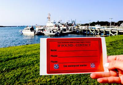
Waterproof stickers for paddle craft with the owner’s name and number help the Coast Guard determine if an abandoned vessel is cause for a full-fledged search and rescue operation.
Campbell Conard
Waterproof stickers affixed to the craft include the owners’ names and phone numbers
By
Campbell Conard

Summer is not over yet. In fact, the next few weeks may be among the best of the year for getting out on the water in small paddle craft like canoes, kayaks, and stand-up paddleboards. But storms and high winds can quickly turn a fun excursion into a dangerous situation, separating paddlers from their craft.

When the United States Coast Guard receives a call of an abandoned vessel on the water, it must dispatch a team to begin a search and rescue operation to ensure that the paddler hasn’t been separated from the vessel in an accident. If someone is in trouble it is the Coast Guard’s responsibility to find and rescue them; but sometimes, that abandoned vessel has simply been carried offshore by winds or high tides and the Coast Guard will have spent time and resources on an operation that is unnecessary. 

To solve this problem in the Northeast, the Coast Guard has introduced an optional “If Found” sticker program for small paddle craft. Waterproof stickers affixed to the craft include the owners’ names and phone numbers, giving the Coast Guard an easy way to figure out if an abandoned vessel was occupied at the time it was lost. If the owner of the paddle craft answers, and confirms that no one was on it, the Coast Guard can make arrangements to return it to its owner. If no one responds, or if someone picks up and confirms that an individual was aboard the vessel, a search and rescue operation will continue. 

The Montauk Coast Guard Station has already handed out thousands of “If Found” stickers, which are available at the station on Star Island and from kayak and paddleboard dealers. 

The stickers not only help to keep individuals separated from vessels safe, but they are also are a way for the public to help the Coast Guard. “The ‘If Found’ stickers are not required by law, but they do help out a lot,” said Senior Chief Petty Officer Eric Best.

There are also other recommended safety precautions when operating a paddle craft. A lifejacket and a whistle are required at all times for those paddling outside of a designated swimming area. “We are focusing on lifejackets because they keep people safe, and whistles because they can be used to efficiently get the attention of people onshore or of other vessels if an individual is in distress,” Officer Best said.

The Coast Guard also recommends using a float plan form, which can be filled out with trip details and emailed to a friend or family member, who can check in and make sure you are back by your planned time.

Nature Notes: Shifting Sands, Lands

Nature Notes: Shifting Sands, Lands

At some point, the inlet to Northwest Creek from Northwest Harbor was arbitrarily moved from the east side to the west, so it now hugs Barcelona Neck.
Matthew Charron
Some popularly known local spots didn’t exist three centuries ago
By
Larry Penny

The recent to-do about Cartwright Island raises some interesting questions. We are sometimes prone to think of the present as the past, East Hampton today has always been, Southampton has always been, Lake Montauk has always been the way it is, etc., etc., etc. But in fact things, including our local landmasses and their surrounding waters, are fluxing every minute, during the day when we can see the change and at night when most of us are sleeping. So it is with the contours of the South Fork’s north and south coastlines. On land, the high points are slowly wearing down or accreting from material settling in from the atmosphere. On a larger scale, Long Island is attached to the rest of New York, and all of New York and the rest of the United States are very slowly moving westerly, away from the mid-Atlantic rift.

Much of our land after purchase from the Native Americans was deeded out to the original settlers and their kin. The names Russel’s Neck and Jessup’s Neck refer to two longstanding peninsulas jutting out into the Peconic Estuary in East Hampton and Noyac, now popularly referred to as Barcelona Neck and the Elizabeth Morton National Wildlife Refuge. The names of geographic points of interest didn’t necessarily change with new ownership. If so, Barcelona would have deferred to the name Heller’s Point after Ben Heller, the last owner before New York State purchased it.

It is very interesting examining the old maps of eastern Long Island in my possession, some of which go back to 1838, when the U.S. Coast Survey teams were busy mapping America’s coasts, and are signed by a senior surveyor to further authenticate them. The last named federal authority morphed into U.S. Coast and Geodetic Survey, which continued the mapping and setting of federal monuments, many originals of which still exist today. These old maps and the later ones produced by the U.S. Geological Survey are extremely valuable in plotting changes in our landscape and seascape over the past 200 years or so.

Some popularly known local spots didn’t exist three centuries ago. For example, there is a 1787 map of the north coast of the Napeague isthmus that shows Napeague Bay without its Hicks Island. Obviously, sand building to the west from Goff Point and sand moving east from Promised Land had something to do with its formation during the 1800s. After the little island’s formation, inlets were created by floodwater breakthroughs, such that Napeague Harbor became partially separated from Napeague Bay. For a long time the island was a peninsula attached to Lazy Point, and stably so, to the degree that a fish-rendering factory was built on it, a remnant of which is still evident. The 1938 Hurricane came along and broke through such that the west inlet was recreated, and the harbor then had two inlets for the next 70 years or so. For the last eight years or so, the east inlet has been blocked with sand. Only the west inlet remains and was re-dredged by Suffolk County in 2014.

If we add little Hog Creek harbor to the list, Napeague Harbor is one of six East Hampton Town harbors from Northwest Creek on the west to Lake Montauk on the east that open to the Peconic Estuary. Three Mile Harbor, which sits to the east of Northwest Harbor and opens into Gardiner’s Bay, is the only one with an inlet that hasn’t changed since recorded history. The inlet to Northwest Creek from Northwest Harbor was arbitrarily moved from the east side to the west, so it now hugs Barcelona.

The inlet to Accabonac Harbor was recreated such that Louse Point was lengthened, and Gerard Point was shortened. The movement to the north was then accented and further stabilized with a rock jetty built out into the bay at the shortened point. 

Lake Montauk, once the largest freshwater pond on the whole of Long Island, was inletted to Block Island Sound in the mid-1920s and then stabilized with a rock revetment on either side shortly after. As a result, the east side, or Gin Beach side, has built out as the east jetty trapped sand flowing to the west from the north side of Montauk, while the west side has retreated as much as 350 feet to the south, according to a U.S. Geodetic Survey map published in the 1930s.

Sand spits very rarely shorten, but mostly lengthen. Such it is that the Cedar Point sand spit bordering Gardiner’s Bay on the north and Northwest Harbor on the south has extended all the way to Cedar Island, where the Cedar Island Lighthouse stands, and beyond — about 200 feet since 1838.

The 1838 U.S. Coast Survey map has little black dots along the land from Cedar Point County Park on the west to Three Mile Harbor on the east. These dots are taken to be glacial erratics, which fell from the bluff that has been receding to the south while providing the sands for the extension of Cedar Point.

Back to Cartwright Island. It comes and goes with each severe northeaster or tropical storm. It has to fight sea level rise, but it is still fed somewhat from sand moving south along either side of Gardiner’s Island’s south spit, from which it separated. I suppose there is enough sand washing away from both the east and west sides of Gardiner’s Island proper to eventually create additional Cartwright Islands to the south of the existing one.

From April through mid-August, Cartwright Island is an important nesting area for federally endangered and threatened terns and threatened piping plovers as well as oystercatchers and other colonial nesting water birds. The East Hampton Town Natural Resources Department used to take care of them. The spit to the north used to be covered with several active osprey nests built on the sand, some three or four feet high when I visited with Paul Stoutenburgh in the mid-1950s.

But let us not forget little no-longer Hicks Island, in this regard. When there were two inlets, there were piping plovers, roseate terns, least terns, and common terns nesting on it. Before the Natural Resources Department started overseeing it, Carl Safina and his Audubon crew watched over it. Now, no longer isolated, it is hunted over by fox and other mammals and is no longer the most productive piping plover and least tern breeding habitat in East Hampton Town.

That same east inlet, which was maintained year after year, also provided fresh tidal water for a band of eelgrass that ran from north to south along the east side of the harbor. It was the only large eelgrass bed in East Hampton to survive the brown tides of the 1980s and eventually became a Town Trustee Eelgrass Sanctuary.

Two weeks ago, I bumped into the private consultant who put together the last plan for Napeague Harbor under the guise of the Peconic Estuary Program, overseen by the Suffolk County Department of Ecology. The plan’s final recommendation was for maintaining the west inlet at the expense of the east one. When I questioned the wisdom of his decision, “One water body, one inlet” was his reply, a new rule of thumb that apparently the county has adopted. So much for the birds! 


Larry Penny can be reached via email at [email protected].

A Break in Fishing Doldrums

A Break in Fishing Doldrums

John Tondra caught and released this Atlantic bonito near Montauk with Capt. Paul Dixon of Off the Point Charters.
Capt. Paul Dixon
A change in the game plan is greatly needed to recharge the enthusiasm
By
Jon M. Diat

When boating or sailing, there are times as the season moves along that doing the same thing over and over becomes downright boring. The same is true for the pursuit of fish. I simply get burned out when chasing the same species day after day. 

I usually partake in a steady diet of fluke and sea bass, mixed with a sprinkling of striped bass and bluefish. The fishing is usually very reliable. But after a certain number of trips, I get bored. The challenge is just not there. A change in the game plan is greatly needed to recharge the enthusiasm.

Thankfully, that happened on Saturday at Montauk, as my annual offshore trip for codfish was on the docket. The trip came at the perfect time to help break the fishing doldrums. 

We departed promptly at 6 a.m. on the charter boat Breakaway, a 42-foot Torres with a much-appreciated air-conditioned main cabin that made the two-hour ride in rather choppy seas a pleasure. I was even able to get a few nods of sleep in one of the forward bunks.

Setting up on the drift in the southwesterly breeze with freshly shucked skimmer clam baits, our offerings were met instantly by large, hungry black sea bass. It rarely took more than a second or two before a fish was on the hook. The bite was intense.

In short order, we captured our limit of three fish per person for the four-man crew (note that the limit increases to seven fish per person on Sept. 1). When not being instantly inhaled by sea bass, our hooks were lucky enough to land three keeper codfish (cod must be at least 22 inches in order to be retained) on our first drop.

Filled in our quest for sea bass, it was time to focus solely on cod, our main quarry. After steering eastward into the deeper, and hopefully cooler, waters that codfish prefer, the first few drops produced a few small red hake that were quickly released. Being patient, we all knew it would take time to find the right spot. And we did. 

We ended up with about 18 cod up to 15 pounds — a very successful trip in any book. Most important, it was great to fish for something different with nary a single boat in sight. The blahs were cured.

“Lots of porgies around everywhere,” exclaimed Harvey Bennett of the Tackle Shop in Amagansett. “It’s sometimes even hard to get away from them.” Bennett said that fluke fishing is holding up on the bayside as well as from the ocean beach. “And with the recent east wind, the striped bass fishing turned on,” he added. “Plus, snappers are keeping the kids entertained, too.”

Speaking of kids, last Thursday, the East Hampton Sportsmen’s Alliance held its fifth annual Take-a-Kid-Fishing trip out of Montauk aboard the Miss Montauk II. The sunset fishing excursion focused on sea bass and porgies for the 40 or so kids who were fortunate enough to fish for free. And at the conclusion of their adventure, they were not disappointed.

“The kids had a ball,” said Terry O’Riordan, director of the alliance and a main coordinator of the popular excursion. “Everyone went home with fish and there were big smiles all around the boat.” A number of raffles and prizes, including several custom-made fishing rods, were handed out by the end of the trip. Nothing better than seeing a kid with a big smile holding a fish at the end of his or her line.

“Fluke fishing has been good, but it is more about quality than quantity,” said Kathy Vegessi of the Lazybones out in Montauk. “The size of the fish has been impressive and we are also seeing a lot of sea bass in the catch as well.” The ’Bones had fluke up to 11 pounds in recent days.

“Fishing has been good when the weather allows,” said Ken Morse at Tight Lines Tackle in Sag Harbor. “Porgies, weakfish, and kingfish are in the bays, and bluefish can be had on diamond jigs on the incoming tide at Jessup’s Neck.” 

On the commercial side, the New York State Department of Environmental Conservation announced that the commercial black sea bass fishery will reopen on Monday, five days earlier than expected. The commercial fishery was closed on July 28 due to projected landings approaching the total allowed for the quota period covering July 1 through Aug. 31, but rough weather resulted in much lower landings during the last open week of fishing. Approximately 10,000 pounds remain available for harvest through Aug. 31.

“We look forward to a productive season as we continue to seek federal regulatory changes to create additional and equitable opportunities for New York’s commercial fishing community,” said Basil Seggos, commissioner of the D.E.C. Only time will tell if that comes to fruition for the overly abundant fish.

We welcome your fishing tips, observations, and photographs at [email protected]. You can find the “On the Water” column on Twitter at @ehstarfishing.

Feeling Hot, Hot, Hot

Feeling Hot, Hot, Hot

While fly-casting from shore, Harris Stoker landed and released this small striped bass off Navy Beach.
I love to get up early and take it all in
By
Jon M. Diat

Hands down, dawn is my favorite part of the day. No matter the season, I love to get up early and take it all in. 

With a hot cup of black coffee in hand, watching the different palettes of color change before your eyes as the sun slowly makes its way above the water in the eastern horizon gives you a different picture every day. Life is usually peaceful and beautiful at that early hour, no matter the weather.

But the recent stretch of very warm temperatures punctuated by dense, tropical humidity with little airflow also illustrated a painting that’s much more abstract. In short, you know it’s just plain uncomfortable outside as you peer from the window inside the coolness of your air-conditioned living room. It’s really not an inviting or pretty picture.

Last week, I should have paid closer heed to those signs. After playing two hours of tennis in the blazing midday sun and suffering through some rather intense leg cramps as a result of severe dehydration while trying to sleep that night, I decided I would go on my boat early the next morning to check and rebait the lobster traps before the sun had gained its full grip on the water and terra firma. Spoiler alert: It was a bad decision.

As expected, the morning dawned hot and humid with nary a wisp of wind. It was dead calm. Even with the added jolt of caffeine from my coffee, it was almost hard to take a breath of air as I untied the boat from the dock while the angry orange glow of the sun rose above the thick haze that hung lazily over Northwest Harbor. It was difficult to move about in the dense conditions.

The one-hour ride to the lobster grounds over the smooth-as-glass water was uneventful, but the sweat began to grow quickly on my brow when I pulled up the first lobster trap by hand. The second trap proved problematic, as it was deeply wedged between some rocks below. Some maneuvering of the boat in the strong incoming tide ultimately pried it loose, but the repeated strain on my arms and back caused the rest of my body to quickly overheat and begin to break down. 

I usually wear a weightlifting belt to provide added support to my increasingly delicate lower back. However, for whatever reason I forgot to strap it across my lower abdomen that morning. A very dumb decision in hindsight, as it only exacerbated my discomfort. Getting older does not always make one smarter.

After pulling up the remaining 13 traps, I was sweating profusely and was,  admittedly, totally exhausted. Encased in my oilskin bibs and size-16 heavy rubber boots, my white cotton shirt was completely drenched in perspiration. Not only that, I had become dizzy and nauseated and had developed a strong headache. If I were a cooked turkey, my red plastic pop-up timer would have been fully extended. I was well done. I felt awful.

Drinking a few bottles of water on the ride back did not improve my condition. My partner that morning on board to help rebait traps also felt woozy. In my blurry mind, at least I had company. But heat exhaustion had clearly set in. It was a rather helpless feeling.

I don’t recall how many lobsters we caught that morning. It’s kind of fuzzy, looking back. Probably 10 or so. All I knew is that it took three days for me to regain my strength and return to normal. 

While I love the summer months, I have to admit that I’m also anxiously awaiting September and some much-anticipated cooler weather. At my age, I learned a pretty good lesson that day. The body has its limits.

Speaking of overheated, the fishing remains solid out in Montauk.

Large striped bass continue to make their presence felt on live baits and on the troll in the rips east of the Montauk Lighthouse, while sea bass, porgy, and fluke continue to be on the chew in their usual summertime haunts. 

“Striped bass and bottom fishing remains red hot,” said Capt. Rob Aaronson of the charter boat Oh Brother! Far offshore, blue-water anglers are also doing well with yellowfin, bigeye, and mahi mahi making up most of the catch, while a few white marlin have also been caught and released. 

Farther west, Harvey Bennett, the owner of the Tackle Shop in Amagansett, was giddy with excitement about the local fishing scene, too. “Fishing has been excellent all around,” he said on Monday morning after stepping out of his well-aged, lime green Volkswagen Beetle, known affectionately as the “Fish Bug.” 

“Fluke fishing at Napeague and even from the surf in Amagansett has been really good of late,” he said. “Lots of bass around too, and porgies and sea bass are plentiful in Gardiner’s Bay and Block Island Sound.” Bennett added that kingfish, along with porgies, can be had off the dock in Fort Pond Bay in Montauk, while bluefish abound along the bayside. 

“Some false albacore are around, too,” he added before unfurling his equally-aged American flag outside his storefront. “And don’t forget that the snappers are getting bigger for the kids and are around just about every dock and bulkhead.”

Bennett also showcased some recently donated baseball gloves, as he continues his yearlong quest to secure new and used baseball equipment for underprivileged children in the Dominican Republic. “I will take anything, I’m not choosy at all,” he said. “The kids down there appreciate just about anything they will receive. Keep on checking that closet, attic, garage, or basement.”

At Mrs. Sam’s Bait and Tackle in East Hampton, Sebastian Gorgone was encouraged by the fluke bite. “Lots of good action on fluke from Napeague to Gardiner’s, but it sometimes can be tough trying to avoid all of the porgies that are around. Other than that, stripers are in the wash along the ocean beaches and the snappers are getting bigger by the day for the kids.”

“Hordes of every type of bait you can think of are around,” said Capt. Paul Dixon of To the Point charters in East Hampton, a light-tackle expert. “There are lots of different sizes of bluefish around, plus mackerel and some striped bass. I’m hearing reports of some bonito around, but I have not seen them myself.”

“Small bluefish are thick on the flood tide at Jessup’s Neck,” said Ken Morse at Tight Lines Tackle in Sag Harbor. “Lots of times they are on top so any surface lure will work. Otherwise a diamond jig does the trick.” Morse said that small striped bass are mixed in with the blues. “And porgies and weakfish have been consistent at Buoy 16 in Noyac Bay,” he added. “Fishing has been pretty hot.”

No need to explain what hot means to me. 

We welcome your fishing tips, observations, and photographs at [email protected]. You can find the “On the Water” column on Twitter at @ehstarfishing.

Nature Notes: Return of the Bobwhite

Nature Notes: Return of the Bobwhite

The bobwhites have flown the coop. Jessica James of Montauk stood by an empty cage after helping to release juvenile bobwhite quail at Montauk County Park on Saturday.
Jane Bimson
Juvenile bobwhite after bobwhite fluttered off into the green tapestry of Montauk County Park
By
Larry Penny

On Saturday the rains came, but it didn’t spoil the first ever release of bobwhites in the hamlet of Montauk by the Third House Nature Center group. Juvenile bobwhite after bobwhite fluttered off into the green tapestry of Montauk County Park atop the hills east of Lake Montauk. Such release of this quail species, native to most of the United States, but not common anywhere, could be the beginning of the comeback of it not only in Montauk, but in the rest of East Hampton Town as well. Two more release days are planned by fall in this five-year program.

The first order of priority in beginning such a repopulation effort, one of several across Long Island, is having a stock of bobwhites to release. For that you need a dedicated individual — not a paid government bureaucrat, mind you, but some ordinary private citizen with a little extra time on his or her hands and a place to hatch and raise chicks safely and lovingly. While the New York State Department of Environmental Conservation raised pheasants in Ridge, in Brookhaven Town, in the 1950s, such operations have ceased and now it is up to dedicated volunteers to take on the challenges.

Such it was that in Montauk along came Jessica James, a woman who raises chickens, is a community activist, an E.M.T., vice president of Concerned Citizens of Montauk, a member of the hamlet’s citizens advisory committee, and a volunteer where and when good causes arise, the re-establishment of the bobwhite population being a very good cause.

Growing up in New Jersey, she summered with her parents in a Leisurama house in Montauk, just east of Culloden, west of Lake Montauk, and south of Block Island Sound. When she was 13 she made plans to one day return to Montauk and establish her home there; she even drew up plans for the house she wanted to build and live in. Forty years later after living in England, California, and scurrying here and there, her dream came true. She now lives in the house of her childhood dreams south of the state golf course surrounded by lush vegetation and varicolored chickens.

It was Montauk locals who first apprised her of the old days when bobwhites and ruffed grouse were not uncommon. They raised the possibility that the Lyme disease outbreak of the 1980s and the black-legged tick that was the cause of it may have had something to do with the bobwhite shortage. It is well known that quail just out of the egg are precocial and will begin feeding on tiny creepy-crawlers including ticks. Why not bring back the bobwhite and see if the tick population that has plagued Montauk for 40 years decreases accordingly?

She knew about the Third House Nature group newly established at the Montauk County Park east of Lake Montauk, and its tireless efforts to educate and preserve Montauk’s flora and fauna, so she went to that group with the idea. Of course, the members applauded it and she was on her way. First, she had to find sources of bobwhite eggs, and she found several, one in Pennsylvania that came with the expert commentary of the individual who had been raising quail for a long time. Since she had been raising chickens for a long time she had very little trouble incubating quail eggs, hatching them out, and dividing the hatchlings into family groups where individual quail chicks would get to know one another and form coveys.

She soon discovered one bothersome fact that can put a damper on quail husbandry: Some chicks are more aggressive than others and will peck at other chicks, killing them unless they are removed. It is this same perpetual pecking nature that keeps the chicks alive and growing and might serve to reduce the ambient tick population. When you spend hours and hours, weeks and weeks, months and months raising a unique species you get to know its ways better than anyone.

While a student at University of California Santa Barbara, I raised paradise fish, a colorful species from Southeast Asia and a relative of the popular Siamese fighting fish. I once had thousands of them and after two intense years of fish culturing almost became more of a paradise fish than a human.

The Suffolk County park rangers were supportive of Jessica’s efforts. Ticks, of course, are a major problem in Suffolk County parks, many of which have habitats of low shrubs and grasses that ticks thrive in. During the release on Saturday, parks employees and other county workers were present, as were several of Montauk’s old-timers.

It rained on and off for a few days after that, and so it remains to be seen how the liberated chicks will fare. It is not expected that all will escape the grasps of hawk talons, foxes, weasels, feral cats, and the occasional wild dog, but some should. And the promise of two more releases this year, as well as many more over the five years of the raise-and-release program, bodes well for Montauk. 

But it wouldn’t be at all possible if it weren’t for a woman who as a child summered in Montauk, came back to the place of her choice after many years away, and settled in to help keep Montauk as she remembered it, an Eden for plants, wildlife, and people.

Larry Penny can be reached via email at [email protected].